
Walking Trails
Walking Trails
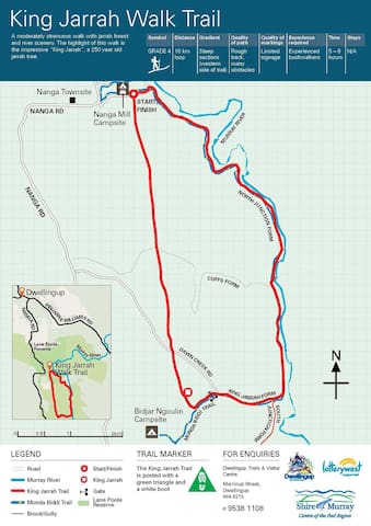
The King Jarrah Track is a 18km loop, grade 4 trail with steep sections suited for more experienced walkers. It is a lovely walk through Jarrah forest.
King Jarrah Track
The King Jarrah Track is a 18km loop, grade 4 trail with steep sections suited for more experienced walkers. It is a lovely walk through Jarrah forest.
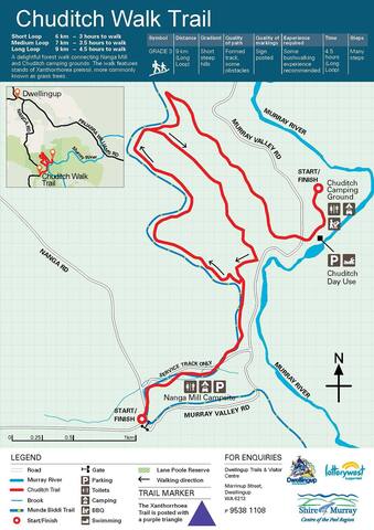
The Chudditch Trail offers walkers 3 loop distances ranging from 6km, 7km & 9km Grade 3 with some short steep sections
Chuditch campground
River RoadThe Chudditch Trail offers walkers 3 loop distances ranging from 6km, 7km & 9km Grade 3 with some short steep sections
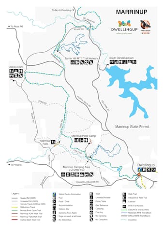
The Marrinup Falls Trail is a stunning, relatively easy Grade 3, 1.4km circuit trail that meanders through lovely native bush; located on Grey Road, north-west from the old Marrinup Town site and camping ground. Enjoy the serenity, scenic views, birdlife, wildflowers in spring, native animals and waterfalls. The best time of year to see the falls flowing is during and just after the winter rains (June to early September).
Marrinup Falls Walk Trail
Grey RoadThe Marrinup Falls Trail is a stunning, relatively easy Grade 3, 1.4km circuit trail that meanders through lovely native bush; located on Grey Road, north-west from the old Marrinup Town site and camping ground. Enjoy the serenity, scenic views, birdlife, wildflowers in spring, native animals and waterfalls. The best time of year to see the falls flowing is during and just after the winter rains (June to early September).
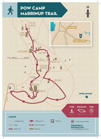
The Marrinup POW camp is a mysterious place with an interesting and surprising history. This trail has recently been upgraded with signage and information; a lovely walk while absorbing some local history. The trail begins at the carpark and the camp entry is approx 300m along the path. There are interpretive information panels at the entry to the camp and the trail follows the original foundations. The best time to walk this trail is in Spring when wildflowers are making a stunning display.
Marrinup P.O.W camp
Grey RoadThe Marrinup POW camp is a mysterious place with an interesting and surprising history. This trail has recently been upgraded with signage and information; a lovely walk while absorbing some local history. The trail begins at the carpark and the camp entry is approx 300m along the path. There are interpretive information panels at the entry to the camp and the trail follows the original foundations. The best time to walk this trail is in Spring when wildflowers are making a stunning display.
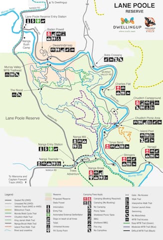
Lane Poole Reserve is a 50,000-ha forested park with hiking/biking trails, campgrounds & a river for boating & fishing.
18 ντόπιοι το προτείνουν
Lane Poole Reserve
Lane Poole Reserve is a 50,000-ha forested park with hiking/biking trails, campgrounds & a river for boating & fishing.
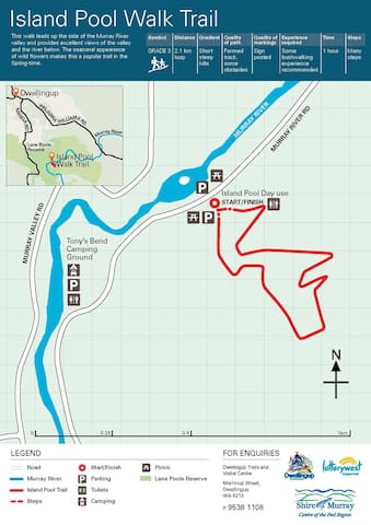
The Island Pool Walk is a 2km grade 3 trail leaves the southern corner of the upper car park at the Island Pool day use area. The trail starts up a flight of steps and a steep rise though jarrah forest and wattles. At this point, the forest begins to thin a little and the balgas (grass tree) become more numerous. Continue along a gentle slope up the valley side.
Balgas begin to dominate as the trail passes between granite outcrops. You are now at the highest part of the trail. There is a seat where you can rest awhile and take in the views of the valley below.
Begin your decent down a gentle slope. The track zig zags for a short distance down a steeper part of the valley side and moves back in to the jarrah forest. From here, it is a short distance back to the upper car park
18 ντόπιοι το προτείνουν
Lane Poole Reserve
The Island Pool Walk is a 2km grade 3 trail leaves the southern corner of the upper car park at the Island Pool day use area. The trail starts up a flight of steps and a steep rise though jarrah forest and wattles. At this point, the forest begins to thin a little and the balgas (grass tree) become more numerous. Continue along a gentle slope up the valley side.
Balgas begin to dominate as the trail passes between granite outcrops. You are now at the highest part of the trail. There is a seat where you can rest awhile and take in the views of the valley below.
Begin your decent down a gentle slope. The track zig zags for a short distance down a steeper part of the valley side and moves back in to the jarrah forest. From here, it is a short distance back to the upper car park
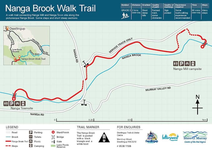
The Nanga Brook Walk Trail passes through the Nanga area, which was once a thriving timber mill town, operating from 1900 until the devastating fires of 1961. The trail can be started from either Nanga townsite or Nanga Mill campground.
Entrance to the trail at Nanga Townsite is towards the western end of the campground, opposite a parking bay, near the brook. Pass the trailhead sign through a grove of tea trees down to the creek across the bridge, then uphill thought the dense undergrowth of the jarrah forest. The trail meanders along Nanga Brook through to Nanga Mill campground assisted from time to time with wooden steps. The walk returns along the same path to Nanga Townsite where the remains of orchards planted by the early residents can be seen.
Entrance to the trail at Nanga Mill campground is towards the eastern end of the site, above the small wooden bridge that crosses the creek.
Nanga Mill Campground
The Nanga Brook Walk Trail passes through the Nanga area, which was once a thriving timber mill town, operating from 1900 until the devastating fires of 1961. The trail can be started from either Nanga townsite or Nanga Mill campground.
Entrance to the trail at Nanga Townsite is towards the western end of the campground, opposite a parking bay, near the brook. Pass the trailhead sign through a grove of tea trees down to the creek across the bridge, then uphill thought the dense undergrowth of the jarrah forest. The trail meanders along Nanga Brook through to Nanga Mill campground assisted from time to time with wooden steps. The walk returns along the same path to Nanga Townsite where the remains of orchards planted by the early residents can be seen.
Entrance to the trail at Nanga Mill campground is towards the eastern end of the site, above the small wooden bridge that crosses the creek.