
HIKING
HIKES
A scenic high-desert climbing area situated above the town of Lone Pine with Mt Whitney and the Sierra crest as a backdrop. Close to 300 routes (trad and sport) on variable quality Josh-like rock. Stacks of easy to moderate well-protected climbs here as most development is quite recent. Free camping nearby with Bishop only an hour away. A fun laid-back area that is a MUST SEE!
10 ντόπιοι το προτείνουν
Alabama Hills
A scenic high-desert climbing area situated above the town of Lone Pine with Mt Whitney and the Sierra crest as a backdrop. Close to 300 routes (trad and sport) on variable quality Josh-like rock. Stacks of easy to moderate well-protected climbs here as most development is quite recent. Free camping nearby with Bishop only an hour away. A fun laid-back area that is a MUST SEE!
Located near Horseshoe Meadows, the Cottonwood Lakes Basin has many pristine alpine lakes and creeks located between Mount Langley and Cirque Peak. Side trails branch to Muir Lake, Hidden Lake, South Fork Lakes, Cirque Lake. Along the trail to New Army Pass are Long Lake and High Lake in the John Muir Wilderness. Climbing over New Army Pass the trail continues into Sequoia National Park and eventually joins the Pacific Crest Trail.
Cottonwood Lakes
Located near Horseshoe Meadows, the Cottonwood Lakes Basin has many pristine alpine lakes and creeks located between Mount Langley and Cirque Peak. Side trails branch to Muir Lake, Hidden Lake, South Fork Lakes, Cirque Lake. Along the trail to New Army Pass are Long Lake and High Lake in the John Muir Wilderness. Climbing over New Army Pass the trail continues into Sequoia National Park and eventually joins the Pacific Crest Trail.
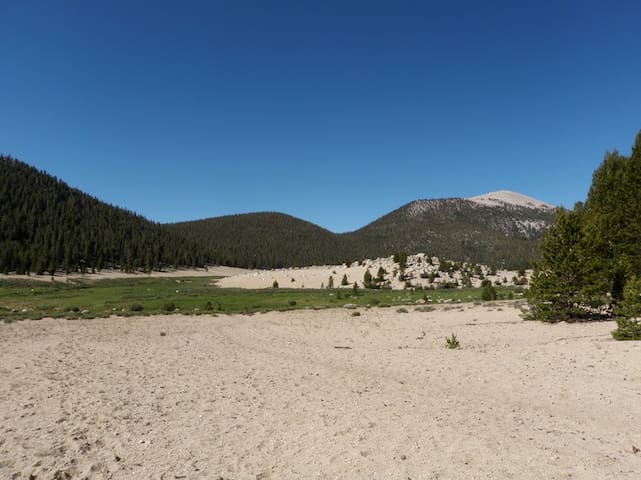
Horseshoe Meadow is a vast 10,000 foot high meadow, surrounded by lodgepole pine forest. Getting there is an adventure in itself; the road to Horseshoe Meadow climbs over 6,000 feet, as it winds its way up from Lone Pine. Three campgrounds are located in the Horseshoe Meadow Area. Trails from Horseshoe Meadow provide access to the Golden Trout Wilderness and Sequoia-Kings Canyon National Park. The road to Horseshoe Meadow is closed from approximately November to May due to snow.
Horseshoe Meadow
Horseshoe Meadow is a vast 10,000 foot high meadow, surrounded by lodgepole pine forest. Getting there is an adventure in itself; the road to Horseshoe Meadow climbs over 6,000 feet, as it winds its way up from Lone Pine. Three campgrounds are located in the Horseshoe Meadow Area. Trails from Horseshoe Meadow provide access to the Golden Trout Wilderness and Sequoia-Kings Canyon National Park. The road to Horseshoe Meadow is closed from approximately November to May due to snow.
The Little Lakes Basin is truly an extraordinary place. An easy trail ascends along a succession of gorgeous glacial carved lakes set amid pretty meadows framed by the spectacular 13,000-ft peaks of Bear Creek Spire, Mt. Dade, Mt. Abbot, Mt. Mills and Mt. Morgan. In summer, the snow is cleared away to reveal a narrow road that winds up the canyon for 10 miles. Rock Creek Road starts in Crowley Lake at Tom’s Place (elevation 7,090 feet) and ends at Mosquito Flat trailhead (elevation 10,250 feet, the highest trailhead in the Sierra). That means you gain an astounding 3,210 feet in elevation as you drive!
Little Lakes Valley Trailhead (Gem Lakes)
Little Lakes Valley TrailThe Little Lakes Basin is truly an extraordinary place. An easy trail ascends along a succession of gorgeous glacial carved lakes set amid pretty meadows framed by the spectacular 13,000-ft peaks of Bear Creek Spire, Mt. Dade, Mt. Abbot, Mt. Mills and Mt. Morgan. In summer, the snow is cleared away to reveal a narrow road that winds up the canyon for 10 miles. Rock Creek Road starts in Crowley Lake at Tom’s Place (elevation 7,090 feet) and ends at Mosquito Flat trailhead (elevation 10,250 feet, the highest trailhead in the Sierra). That means you gain an astounding 3,210 feet in elevation as you drive!
Mt. Whitney Trail climbs over 6,000 feet in 11 miles. When free of snow, it provides a strenuous, non-technical route to the summit of Mt. Whitney. Additional skills and equipment are necessary for safe travel when snow and ice are present. The trail is usually relatively snow-free from late June to mid-October.
6 ντόπιοι το προτείνουν
Mount Whitney
Mt. Whitney Trail climbs over 6,000 feet in 11 miles. When free of snow, it provides a strenuous, non-technical route to the summit of Mt. Whitney. Additional skills and equipment are necessary for safe travel when snow and ice are present. The trail is usually relatively snow-free from late June to mid-October.
Trails from Onion Valley provide acces to the John Muir Wilderness and Kings Canyon National Park. In the spring, Onion Valley is popular with backcountry skiers and snowboarders. The road to Onion Valley is usually open from May to November.
Onion Valley
Trails from Onion Valley provide acces to the John Muir Wilderness and Kings Canyon National Park. In the spring, Onion Valley is popular with backcountry skiers and snowboarders. The road to Onion Valley is usually open from May to November.
Beginning at Onion Valley, the Kearsarge Pass Trail travels through the John Muir Wilderness. The trail climbs through forest and alpine tundra and past several lakes, including Little Pothole, Gilbert, and Flower Lakes. It is 4 miles to the top of 11,700-foot Kearsarge Pass. Beyond the pass, the trail continues into Kings Canyon National Park, where it joins the John Muir Trail near Bullfrog Lake. From the trailhead at Onion Valley to the John Muir Trail junction is 6.5 miles.
Kearsarge Pass Trailhead
Onion Valley RoadBeginning at Onion Valley, the Kearsarge Pass Trail travels through the John Muir Wilderness. The trail climbs through forest and alpine tundra and past several lakes, including Little Pothole, Gilbert, and Flower Lakes. It is 4 miles to the top of 11,700-foot Kearsarge Pass. Beyond the pass, the trail continues into Kings Canyon National Park, where it joins the John Muir Trail near Bullfrog Lake. From the trailhead at Onion Valley to the John Muir Trail junction is 6.5 miles.
Golden Trout Lakes Trail
Starting from Onion Valley, Golden Trout Lakes Trail ends at Golden Trout Lakes, in the John Muir Wilderness. The distance to the lakes is approximately 2.2 miles, and the elevation gain is approximately 2,200 feet. This trail is steep, rugged and difficult to follow.
Golden Trout Lake
Golden Trout Lakes Trail
Starting from Onion Valley, Golden Trout Lakes Trail ends at Golden Trout Lakes, in the John Muir Wilderness. The distance to the lakes is approximately 2.2 miles, and the elevation gain is approximately 2,200 feet. This trail is steep, rugged and difficult to follow.