
Wrightys Guidebook
Sightseeing
Stunning place to visit for a day with various things on offer.
Tour of the main house,
Visit to the Farmyard (great for the kids)
Take a picnic into the gardens - designed by Capability Brown and with an amazing cascade and maze to wander around.
You can park at the house (although you need to pre book at the moment due to COVID).
If you want to visit Chatsworth without spending to much as it can be pricey, I would suggest parking in Baslow village and walking to Chatsworth house - directions are easy if you park in the pay and display car park and wander through the estate to the main house
https://www.chatsworth.org/
698 ντόπιοι το προτείνουν
Τσάτσγουορθ Χάους
Stunning place to visit for a day with various things on offer.
Tour of the main house,
Visit to the Farmyard (great for the kids)
Take a picnic into the gardens - designed by Capability Brown and with an amazing cascade and maze to wander around.
You can park at the house (although you need to pre book at the moment due to COVID).
If you want to visit Chatsworth without spending to much as it can be pricey, I would suggest parking in Baslow village and walking to Chatsworth house - directions are easy if you park in the pay and display car park and wander through the estate to the main house
https://www.chatsworth.org/
A small Anglo Saxon village nestled in the hills of Derbyshire, Eyam has become known as the ‘plague village’ due to a decision made by the whole village during an outbreak of bubonic plague in 1665.
According to reports, the plague was brought to the village from London in a bundle of cloth ordered by local tailor George Vicars. He died within a week, and after several more deaths the villagers, on the advice of their rector Reverend William Mompesson, took several steps to ensure that the plague did not spread to neighboring villages.
Families were required to bury their own dead, and ultimately the village quarantined itself, allowing no-one in or out during the fourteen months that the plague took hold. Reported numbers of deaths vary—around 260—but it is said that fewer than a quarter of the village population survived. The self-imposed quarantine did, however, successfully contain the spread of disease.
A little way out of the village, on a hill overlooking the beautiful Peak District, stands a small graveyard known as the Riley Graves, so called as they are close to Riley House Farm. Ringed by a low stone wall, this is the resting place of the Hancock family, where Elizabeth Hancock buried her husband and six of her seven children over a period of eight days in August 1666. She was one of the few survivors, and this obscure gravesite—alone in a field on a hill some way out of the village—is now a National Trust monument.
https://www.eyamvillage.org.uk/
79 ντόπιοι το προτείνουν
Eyam
A small Anglo Saxon village nestled in the hills of Derbyshire, Eyam has become known as the ‘plague village’ due to a decision made by the whole village during an outbreak of bubonic plague in 1665.
According to reports, the plague was brought to the village from London in a bundle of cloth ordered by local tailor George Vicars. He died within a week, and after several more deaths the villagers, on the advice of their rector Reverend William Mompesson, took several steps to ensure that the plague did not spread to neighboring villages.
Families were required to bury their own dead, and ultimately the village quarantined itself, allowing no-one in or out during the fourteen months that the plague took hold. Reported numbers of deaths vary—around 260—but it is said that fewer than a quarter of the village population survived. The self-imposed quarantine did, however, successfully contain the spread of disease.
A little way out of the village, on a hill overlooking the beautiful Peak District, stands a small graveyard known as the Riley Graves, so called as they are close to Riley House Farm. Ringed by a low stone wall, this is the resting place of the Hancock family, where Elizabeth Hancock buried her husband and six of her seven children over a period of eight days in August 1666. She was one of the few survivors, and this obscure gravesite—alone in a field on a hill some way out of the village—is now a National Trust monument.
https://www.eyamvillage.org.uk/
Castleton is a beautiful village situated at the head of the Hope Valley in the heart of the Peak District National Park. The village is popular for its show caves, history, shops, Christmas lights, garland ceremony, Winnats Pass, Cave Dale and for those wishing to walk on the numerous footpaths in the area. Surrounded by hillsides and overlooked by Mam Tor (the shivering mountain) and the ancient Peveril Castle.
It is famous for a stone known as Blue John this is mined to make jewellery, which is sold locally. The mineral crystals were impregnated naturally during the formation with hydro – carbons, possibly altered by latent radio-activity in the rocks, to give them an attractive blue and yellow banding. There are a number of old mines you can visit but the best two are Blue John cavern and Speedwell cavern (you go on a boat through this one).
186 ντόπιοι το προτείνουν
Castleton
Castleton is a beautiful village situated at the head of the Hope Valley in the heart of the Peak District National Park. The village is popular for its show caves, history, shops, Christmas lights, garland ceremony, Winnats Pass, Cave Dale and for those wishing to walk on the numerous footpaths in the area. Surrounded by hillsides and overlooked by Mam Tor (the shivering mountain) and the ancient Peveril Castle.
It is famous for a stone known as Blue John this is mined to make jewellery, which is sold locally. The mineral crystals were impregnated naturally during the formation with hydro – carbons, possibly altered by latent radio-activity in the rocks, to give them an attractive blue and yellow banding. There are a number of old mines you can visit but the best two are Blue John cavern and Speedwell cavern (you go on a boat through this one).
Derwent / Ladybower reservoir
This is the location where the Dambusters practised using the bouncing bomb prior to the raid in Germany.
You can park at fairholmes visitor centre (link below) or on the approach to there is lots of free parking.
Great for walking or you can hire bikes and ride around the reservoir - it will take a couple of hours.
https://www.peakdistrict.gov.uk/visiting/visitor-centres/
https://en.wikipedia.org/wiki/Ladybower_Reservoir
http://www.dambusters.org.uk/reccomendations/derwent-valley-museum/
114 ντόπιοι το προτείνουν
Ladybower Reservoir
Derwent / Ladybower reservoir
This is the location where the Dambusters practised using the bouncing bomb prior to the raid in Germany.
You can park at fairholmes visitor centre (link below) or on the approach to there is lots of free parking.
Great for walking or you can hire bikes and ride around the reservoir - it will take a couple of hours.
https://www.peakdistrict.gov.uk/visiting/visitor-centres/
https://en.wikipedia.org/wiki/Ladybower_Reservoir
http://www.dambusters.org.uk/reccomendations/derwent-valley-museum/
Haddon Hall
A 900-year-old Stately home that has been used as a location for 3 film versions of Jayne Eyre and also Pride and Prejudice.
You can park at hall itself - check before you visit as it has been closed due to COVID.
260 ντόπιοι το προτείνουν
Haddon Hall
Haddon Hall
A 900-year-old Stately home that has been used as a location for 3 film versions of Jayne Eyre and also Pride and Prejudice.
You can park at hall itself - check before you visit as it has been closed due to COVID.
Great walk/run with amazing views
Curbar Edge / Baslow Edge
One of my favourite places to walk in the area you get spectacular views of the area from both edges - park at Curbar gap car park or various places on the road up to the edge - very busy at weekends.
Great little coffee van situated in the car park at weekends.
https://www.peakdistrict.gov.uk/__data/assets/pdf_file/0026/92762/Miles-without-Stiles-Route-4.pdf
42 ντόπιοι το προτείνουν
Curbar Edge
Curbar Edge / Baslow Edge
One of my favourite places to walk in the area you get spectacular views of the area from both edges - park at Curbar gap car park or various places on the road up to the edge - very busy at weekends.
Great little coffee van situated in the car park at weekends.
https://www.peakdistrict.gov.uk/__data/assets/pdf_file/0026/92762/Miles-without-Stiles-Route-4.pdf
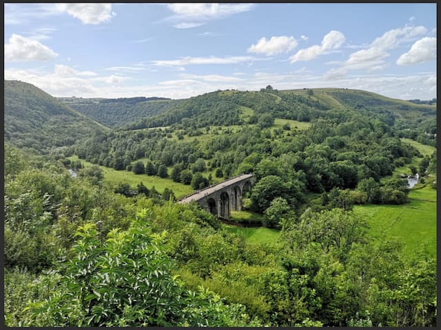
Monsal Head
There is a lovely 10k circular walk that takes you from the house (turn left outside the gates) up Hill Cross, and on to a public footpath called Pennyunk Lane. This takes you all the way to Monsal head where you there is a spectacular view over the Wye valley that takes in the old railway viaduct. (you can stop at the cafe or pub and admire to view)
https://www.visitpeakdistrict.com/things-to-do/monsal-head-and-monsal-dale-p681131
7 ντόπιοι το προτείνουν

Monsal Dale
Monsal Head
There is a lovely 10k circular walk that takes you from the house (turn left outside the gates) up Hill Cross, and on to a public footpath called Pennyunk Lane. This takes you all the way to Monsal head where you there is a spectacular view over the Wye valley that takes in the old railway viaduct. (you can stop at the cafe or pub and admire to view)
https://www.visitpeakdistrict.com/things-to-do/monsal-head-and-monsal-dale-p681131
Chrome Hill is a limestone reef knoll in Derbyshire, England, in the upper Dove valley beside the border with Staffordshire. It is adjacent to Parkhouse Hill, another reef knoll. Chrome Hill was declared open access land under the provisions of the Countryside and Rights of Way Act 2000
25 ντόπιοι το προτείνουν
Chrome Hill
Chrome Hill is a limestone reef knoll in Derbyshire, England, in the upper Dove valley beside the border with Staffordshire. It is adjacent to Parkhouse Hill, another reef knoll. Chrome Hill was declared open access land under the provisions of the Countryside and Rights of Way Act 2000
The Roaches is a prominent rocky ridge above Leek and Tittesworth Reservoir in the Peak District of England. The ridge with its rock formations rises steeply to 505 m. Along with Ramshaw Rocks and Hen Cloud they form a gritstone escarpment, which is popular with hikers, rock climbers and freerunners.
90 ντόπιοι το προτείνουν
The Roaches
The Roaches is a prominent rocky ridge above Leek and Tittesworth Reservoir in the Peak District of England. The ridge with its rock formations rises steeply to 505 m. Along with Ramshaw Rocks and Hen Cloud they form a gritstone escarpment, which is popular with hikers, rock climbers and freerunners.
This is quite a challenging walk but well worth it for the views when you get there
The Alport Castles are a landslip feature in the Peak District National Park in Derbyshire. At over half a mile long, it is thought to be the largest landslide in the United Kingdom
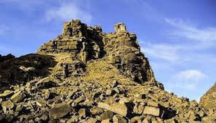
Alport Castles
This is quite a challenging walk but well worth it for the views when you get there
The Alport Castles are a landslip feature in the Peak District National Park in Derbyshire. At over half a mile long, it is thought to be the largest landslide in the United Kingdom
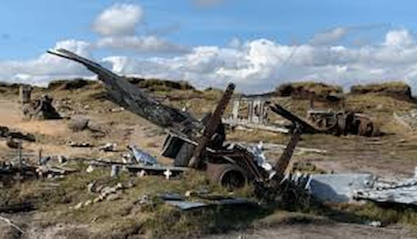
A very challenging walk so do some research first but there are always new things to discover in the Peak District - but you'd normally expect them to be waterfalls or caves rather than ancient plane crashes.
But here in the hills above Glossop, just outside Greater Manchester's borders, you'll find the battered remains of the so-called Bleaklow Bomber.
The plane, which flew under the name 'Over Exposed', crashed here in 1948, tragically killing all 13 passengers on board.
Its remains still lie to this day near Higher Shelf Stones on the moorland plateau, a short distance from Snake's Pass.
There are still large parts of the fuselage intact (Image: Manchester Evening News)
Though a fairly popular attraction for visitors to the area, many locals don't even know the wreckage is here.
For those who do make the walk slightly off the trail to find it, you'll see lumps of metal still recognisable as engines, windows and other parts of the craft's fuselage.
Bleaklow
A very challenging walk so do some research first but there are always new things to discover in the Peak District - but you'd normally expect them to be waterfalls or caves rather than ancient plane crashes.
But here in the hills above Glossop, just outside Greater Manchester's borders, you'll find the battered remains of the so-called Bleaklow Bomber.
The plane, which flew under the name 'Over Exposed', crashed here in 1948, tragically killing all 13 passengers on board.
Its remains still lie to this day near Higher Shelf Stones on the moorland plateau, a short distance from Snake's Pass.
There are still large parts of the fuselage intact (Image: Manchester Evening News)
Though a fairly popular attraction for visitors to the area, many locals don't even know the wreckage is here.
For those who do make the walk slightly off the trail to find it, you'll see lumps of metal still recognisable as engines, windows and other parts of the craft's fuselage.
Picnic spot / walk
Lathkill Dale
Great place for a picnic by the river and a walk on a sunny day.
http://www.peakdistrictonline.co.uk/lathkill-dale-c10113.html
44 ντόπιοι το προτείνουν
Lathkill Dale
Lathkill Dale
Great place for a picnic by the river and a walk on a sunny day.
http://www.peakdistrictonline.co.uk/lathkill-dale-c10113.html
Dovedale is known for the River Dove and it’s impressive limestone ravines, but the most iconic part of a trip to Dovedale has to be the picturesque stepping stones…
Arriving at the nearby car park, where you can also be tempted by snacks and refreshments, it’s just a short walk up and across a wooden bridge to get to the River Dove, where you can look up onto Thorpe Cloud.
Thorpe Cloud is an isolated limestone hill, also known as a reef knoll, which sits between the villages of Ilam and Thorpe and lies right on the border between Derbyshire and Staffordshire. It’s highest point has an elevation of 287 metres, which is quite a quick and steep ascent, but one with lots of hike-worthy views across the Staffordshire and Derbyshire countryside once you’re at the top. If you are planning on walking to the top of Thorpe Cloud do remember to bring a good pair of walking boots with you, as the way down the hill can sometimes be a tad tricky.
Following the River Dove up towards the stepping stones you can cross and climb to the top of Thorpe Cloud, giving fantastic panoramic views of the Peak District.
For a more family friendly walk, you can continue up passed Thorpe Cloud and carry on up along the river. There’s lots of great wildlife and woodland to explore along this riverside stroll, and the path is very clear and flat which is a plus point for families with small children.
If you’d rather take more of a walk to enjoy the Peak District countryside and arrive in Dovedale along the way, there are a few good locations to start. For example, the River Dove flows through Milldale, which is a great starting point for the walk down through Dovedale to the stepping stones, as well as Wolfscote Dale and Beresford Dale. Here there are also a network of footpaths and walks either along the river or over the surrounding countryside.
100 ντόπιοι το προτείνουν
Dovedale
Dovedale is known for the River Dove and it’s impressive limestone ravines, but the most iconic part of a trip to Dovedale has to be the picturesque stepping stones…
Arriving at the nearby car park, where you can also be tempted by snacks and refreshments, it’s just a short walk up and across a wooden bridge to get to the River Dove, where you can look up onto Thorpe Cloud.
Thorpe Cloud is an isolated limestone hill, also known as a reef knoll, which sits between the villages of Ilam and Thorpe and lies right on the border between Derbyshire and Staffordshire. It’s highest point has an elevation of 287 metres, which is quite a quick and steep ascent, but one with lots of hike-worthy views across the Staffordshire and Derbyshire countryside once you’re at the top. If you are planning on walking to the top of Thorpe Cloud do remember to bring a good pair of walking boots with you, as the way down the hill can sometimes be a tad tricky.
Following the River Dove up towards the stepping stones you can cross and climb to the top of Thorpe Cloud, giving fantastic panoramic views of the Peak District.
For a more family friendly walk, you can continue up passed Thorpe Cloud and carry on up along the river. There’s lots of great wildlife and woodland to explore along this riverside stroll, and the path is very clear and flat which is a plus point for families with small children.
If you’d rather take more of a walk to enjoy the Peak District countryside and arrive in Dovedale along the way, there are a few good locations to start. For example, the River Dove flows through Milldale, which is a great starting point for the walk down through Dovedale to the stepping stones, as well as Wolfscote Dale and Beresford Dale. Here there are also a network of footpaths and walks either along the river or over the surrounding countryside.
Neighbourhoods
Bakewell
https://en.wikipedia.org/wiki/Bakewell
A bit of a tourist hot spot especially at the weekends - plenty of paid parking around the town though.
There is a Market every Monday although open on reduced hours at the moment due to COVID - 9.30 to 14.30.
Famous for the Bakewell pudding not Tart - best ones in town are in the old original Bakewell pudding shop - https://www.bakewellpuddingshop.co.uk/
375 ντόπιοι το προτείνουν
Bakewell
Bakewell
https://en.wikipedia.org/wiki/Bakewell
A bit of a tourist hot spot especially at the weekends - plenty of paid parking around the town though.
There is a Market every Monday although open on reduced hours at the moment due to COVID - 9.30 to 14.30.
Famous for the Bakewell pudding not Tart - best ones in town are in the old original Bakewell pudding shop - https://www.bakewellpuddingshop.co.uk/
Ashford in the Water is rightly regarded as one of the prettiest villages in the Peak District. Situated on the northern bank of the River Wye, the village is best explored on foot, there is a triple-arched packhorse bridge which is said to be the most photographed bridge in England. Willow trees overhang the river and, at appropriate times of the year, rainbow trout can be seen leaping in the crystal-clear waters.
There are two pubs in the village, a café, and a corner shop that provides most of what you would need for a short stay in the peak district (closed at the moment as it is changing ownership).
20 ντόπιοι το προτείνουν
Ashford in the Water
Ashford in the Water is rightly regarded as one of the prettiest villages in the Peak District. Situated on the northern bank of the River Wye, the village is best explored on foot, there is a triple-arched packhorse bridge which is said to be the most photographed bridge in England. Willow trees overhang the river and, at appropriate times of the year, rainbow trout can be seen leaping in the crystal-clear waters.
There are two pubs in the village, a café, and a corner shop that provides most of what you would need for a short stay in the peak district (closed at the moment as it is changing ownership).
The Derbyshire village of Hartington is full of charming 18th century houses, an idyllic pond but most importantly, it is home to one of the best local cheese shops in the county (if not the world). Here you can buy delicious locally made cheese such as the Hartington Stilton, Peakland Cranberry and Orange and our personal favourite, Peakland Blue. Click here for a blog all about the Hartington Cheese shop and it’s wonderful produce.
42 ντόπιοι το προτείνουν
Hartington
The Derbyshire village of Hartington is full of charming 18th century houses, an idyllic pond but most importantly, it is home to one of the best local cheese shops in the county (if not the world). Here you can buy delicious locally made cheese such as the Hartington Stilton, Peakland Cranberry and Orange and our personal favourite, Peakland Blue. Click here for a blog all about the Hartington Cheese shop and it’s wonderful produce.
Bike / Walk/ Run
Monsal Trail
You can walk / run or hire bikes on this old railway track.
It is about 8.5 miles long in total and you can join at any point.
The nearest point to our house is in Great Longstone - about a 15 min walk.
The bike hire and cafe are situated at Hassop Station (large car park).
https://www.hassopstation.co.uk/?gclid=CjwKCAjw9vn4BRBaEiwAh0muDIF6oe9rqIAVM8lY5nkvnl5x8yqtqgkASQFoOmyOJsGNA7KyqnkiVBoChfcQAvD_BwE
https://en.m.wikipedia.org/wiki/Monsal_Trail
64 ντόπιοι το προτείνουν
Monsal Trail
Monsal TrailMonsal Trail
You can walk / run or hire bikes on this old railway track.
It is about 8.5 miles long in total and you can join at any point.
The nearest point to our house is in Great Longstone - about a 15 min walk.
The bike hire and cafe are situated at Hassop Station (large car park).
https://www.hassopstation.co.uk/?gclid=CjwKCAjw9vn4BRBaEiwAh0muDIF6oe9rqIAVM8lY5nkvnl5x8yqtqgkASQFoOmyOJsGNA7KyqnkiVBoChfcQAvD_BwE
https://en.m.wikipedia.org/wiki/Monsal_Trail
The London and North Western Railway (LNWR) between Buxton and Ashbourne first opened in 1899. Following the closure of the line around seventy years later, the Peak District National Park bought the route in 1971 and turned it into a traffic free trail for walkers and cyclists.
The Tissington Trail runs for 13 miles from Parsley Hay (53.1706°N 1.7828°W) in the north to Ashbourne (53.0196°N 1.7397°W) in the south.
59 ντόπιοι το προτείνουν
Tissington Trail Car Park, Ashbourne
Leisure WayThe London and North Western Railway (LNWR) between Buxton and Ashbourne first opened in 1899. Following the closure of the line around seventy years later, the Peak District National Park bought the route in 1971 and turned it into a traffic free trail for walkers and cyclists.
The Tissington Trail runs for 13 miles from Parsley Hay (53.1706°N 1.7828°W) in the north to Ashbourne (53.0196°N 1.7397°W) in the south.
Carsington Water is a reservoir operated by Severn Trent Water located between Wirksworth and Kniveton in Derbyshire, England. The reservoir takes water from the River Derwent at Ambergate during winter months, pumping up to the reservoir by 10.5-kilometre long tunnels and aqueduct.
163 ντόπιοι το προτείνουν
Carsington Water
Carsington Water is a reservoir operated by Severn Trent Water located between Wirksworth and Kniveton in Derbyshire, England. The reservoir takes water from the River Derwent at Ambergate during winter months, pumping up to the reservoir by 10.5-kilometre long tunnels and aqueduct.
Derwent Reservoir is a reservoir on the River Derwent, on the border between County Durham and Northumberland, in England. It is west of Consett. It is one of the biggest inland waters in England.
42 ντόπιοι το προτείνουν
Derwent Reservoir
Derwent Reservoir is a reservoir on the River Derwent, on the border between County Durham and Northumberland, in England. It is west of Consett. It is one of the biggest inland waters in England.
The Longdendale Trail is an English long-distance trail following the former Woodhead railway line, which ran between Manchester and Sheffield and closed east of Hadfield in 1981. It has shallow gradients and a smooth surface that makes it popular with families and cyclists
15 ντόπιοι το προτείνουν
Longdendale Trail
4 Platt StThe Longdendale Trail is an English long-distance trail following the former Woodhead railway line, which ran between Manchester and Sheffield and closed east of Hadfield in 1981. It has shallow gradients and a smooth surface that makes it popular with families and cyclists
The Sett Valley Trail is a 2.5 mile recreational trail for walkers, cyclists and horse riders linking New Mills and Hayfield.
It follows a former railway line through outstanding countryside and forms part of the Pennine Bridleway National Trail between Hayfield and Birch Vale.
At New Mills there is access from the Sett Valley Trail to the dramatic Torrs Riverside Park and to Mousley Bottom via the Millennium Walkway.
You can access the Torrs Riverside Park in New Mills, Mousley Bottom via the Millennium Walkway and New Mills Heritage Centre, via the Torrs.
This is an access for all trail, allowing prams and mobility scooters access from New Mills town centre to Hayfield.
The trail is unsuitable for horse riders or cyclists west of St George’s Road, New Mills.
Sett Valley Trail
40 Station RdThe Sett Valley Trail is a 2.5 mile recreational trail for walkers, cyclists and horse riders linking New Mills and Hayfield.
It follows a former railway line through outstanding countryside and forms part of the Pennine Bridleway National Trail between Hayfield and Birch Vale.
At New Mills there is access from the Sett Valley Trail to the dramatic Torrs Riverside Park and to Mousley Bottom via the Millennium Walkway.
You can access the Torrs Riverside Park in New Mills, Mousley Bottom via the Millennium Walkway and New Mills Heritage Centre, via the Torrs.
This is an access for all trail, allowing prams and mobility scooters access from New Mills town centre to Hayfield.
The trail is unsuitable for horse riders or cyclists west of St George’s Road, New Mills.
Mam Tor, meaning ‘Mother Hill’, is a 517 metre high hill near Castleton in the High Peak area of Derbyshire and is one of the most famous walks in the Peak District that well and truly deserves a place on your Peak District bucket list!
Mam Tor sits on the edge of the Dark Peak (gritstone) and the White Peak (limestone) which means you get some fantastic views of the limestone parts of the National Park, such as the dry gorge of Winnats Pass. Winnats Pass is always a favourite amongst
134 ντόπιοι το προτείνουν
Mam Tor
Mam Tor, meaning ‘Mother Hill’, is a 517 metre high hill near Castleton in the High Peak area of Derbyshire and is one of the most famous walks in the Peak District that well and truly deserves a place on your Peak District bucket list!
Mam Tor sits on the edge of the Dark Peak (gritstone) and the White Peak (limestone) which means you get some fantastic views of the limestone parts of the National Park, such as the dry gorge of Winnats Pass. Winnats Pass is always a favourite amongst
Restaurants
Located in the picturesque village of Tideswell in the heart of the Peak District, they provide fresh, locally sourced cuisine and carefully crafted drinks in an atmospheric and friendly environment, where top class service is a priority.
38 ντόπιοι το προτείνουν
The Merchant's Yard
Saint John's RoadLocated in the picturesque village of Tideswell in the heart of the Peak District, they provide fresh, locally sourced cuisine and carefully crafted drinks in an atmospheric and friendly environment, where top class service is a priority.
Perfect for those looking to explore the sights and sounds of the area as it lies equidistant from the beautiful towns of Matlock and Buxton and the Rutland Arms Hotel itself is nestled comfortably on the outskirts of the famous Chatsworth estate. The Rutland Arms Hotel dates back to 1804 and is set in the majestic Peak District National Park in the picturesque town of Bakewell.
13 ντόπιοι το προτείνουν
The Rutland Arms Hotel
Perfect for those looking to explore the sights and sounds of the area as it lies equidistant from the beautiful towns of Matlock and Buxton and the Rutland Arms Hotel itself is nestled comfortably on the outskirts of the famous Chatsworth estate. The Rutland Arms Hotel dates back to 1804 and is set in the majestic Peak District National Park in the picturesque town of Bakewell.
Located in a cosy corner of the Chatsworth Estate, The Devonshire Arms at Beeley is the kind of country Inn that dreams are made of.
25 ντόπιοι το προτείνουν
The Devonshire Arms at Beeley
Devonshire SquareLocated in a cosy corner of the Chatsworth Estate, The Devonshire Arms at Beeley is the kind of country Inn that dreams are made of.
Cafe’s
A great place for breakfast or lunch - all with a Swedish twist
open until 4pm
17 ντόπιοι το προτείνουν
High Nelly's Cafe
2 Bank SquareA great place for breakfast or lunch - all with a Swedish twist
open until 4pm
Spacious old station building housing a bright cafe and terrace, plus a book shop and bikes to hire.
situated right next to the old railway line - can get busy at weekends
62 ντόπιοι το προτείνουν
Hassop Station Cafe and Monsal Trail Cycle Hire
Hassop RoadSpacious old station building housing a bright cafe and terrace, plus a book shop and bikes to hire.
situated right next to the old railway line - can get busy at weekends