
Guidebook for the Retreat
Sightseeing
A stunning stately home having been passed down through 16 generations of the Cavendish Family. The 1000 acres of park on the banks of the River Derwent is popular with International and National visitors all year round. Whether it be visit to the house, its gardens or Chatsworth's renowned annual Country Fair or RHS Chatsworth Flower Show, there is certainly something for everyone.
Why not visit Endensor, a picture post card village situated within the grounds of the estate and call into Chatsworth Farm Shop in the village of Pilsley on the way back.
698 ντόπιοι το προτείνουν
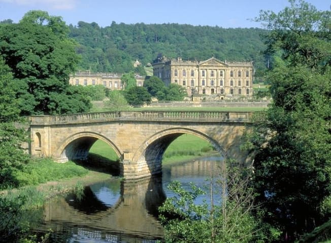
Τσάτσγουορθ Χάους
A stunning stately home having been passed down through 16 generations of the Cavendish Family. The 1000 acres of park on the banks of the River Derwent is popular with International and National visitors all year round. Whether it be visit to the house, its gardens or Chatsworth's renowned annual Country Fair or RHS Chatsworth Flower Show, there is certainly something for everyone.
Why not visit Endensor, a picture post card village situated within the grounds of the estate and call into Chatsworth Farm Shop in the village of Pilsley on the way back.
A small attractive market town known for its Bakewell pudding and nestled by the River Wye.
Bakewell Farmers Market it one not to be missed. Usually held on the last Saturday of the month.
375 ντόπιοι το προτείνουν
Bakewell
A small attractive market town known for its Bakewell pudding and nestled by the River Wye.
Bakewell Farmers Market it one not to be missed. Usually held on the last Saturday of the month.
This is another `must' for your stay.
Would definite recommend a trip to Monsal Head. Not only for the breath taking views of the Monsal Head Viaduct below as it crosses the River Wye, but a well earn't drink or meal at the Stable Bar at Monsal Head after a walk or cycle ride along the Monsal Trail or a walk down into the valley which is equally as breath taking.
The Monsal Trail is a traffic free route for walkers, cyclists, horse riders and wheelchair users through some of the Peak District's most spectacular limestone dales.
The trail runs along the former Midland Railway line for 8.5 miles between Blackwell Mill, in Chee Dale and Coombs Road, at Bakewell.
Most of the route was opened to the public in 1981 but four former railway tunnels had to remain closed due to safety reasons, with public footpaths taking people around them. From 25 May 2011 the four railway tunnels - Headstone Tunnel, Cressbrook Tunnel, Litton Tunnel, Chee Tor Tunnel – will also open for trail users. Each tunnel is about 400 metres long and will be lit during normal daylight hours.
Two shorter tunnels - Chee Tor No.2 and Rusher Cutting – already formed part of the Monsal Trail.
The public can now experience the full length of the former railway route at their own pace and see breathtaking views at places like Water-cum-Jolly Dale that have remained hidden since the railway closed in 1968.
Other former railway lines now open to the public as traffic-free trails can be found at the High Peak Trail and Tissington Trail, with bike hire centres also servicing these routes.
The Monsal Trail tunnels offer one of the most spectacular leisure routes in Britain for cycling, walking and horse riding.
Only recently, It is the first time the public have been able to go through the tunnels since the former Midland Railway Line closed in 1968.
Following work by the Peak District National Park Authority – using £2.25 million funding from the Department of Transport – the tunnels have been repaired, resurfaced and lit to form an extension to the existing Monsal Trail.
Four of the longer tunnels are lit during daylight hours, dawn to dusk, to make them safe to use.
60 ντόπιοι το προτείνουν
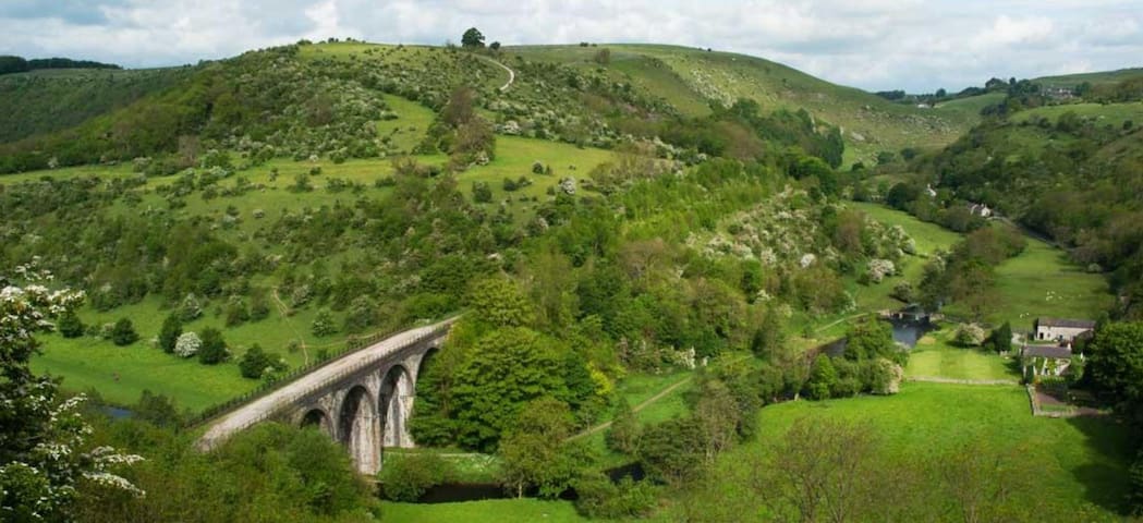
Monsal Head Hotel
Monsal TrailThis is another `must' for your stay.
Would definite recommend a trip to Monsal Head. Not only for the breath taking views of the Monsal Head Viaduct below as it crosses the River Wye, but a well earn't drink or meal at the Stable Bar at Monsal Head after a walk or cycle ride along the Monsal Trail or a walk down into the valley which is equally as breath taking.
The Monsal Trail is a traffic free route for walkers, cyclists, horse riders and wheelchair users through some of the Peak District's most spectacular limestone dales.
The trail runs along the former Midland Railway line for 8.5 miles between Blackwell Mill, in Chee Dale and Coombs Road, at Bakewell.
Most of the route was opened to the public in 1981 but four former railway tunnels had to remain closed due to safety reasons, with public footpaths taking people around them. From 25 May 2011 the four railway tunnels - Headstone Tunnel, Cressbrook Tunnel, Litton Tunnel, Chee Tor Tunnel – will also open for trail users. Each tunnel is about 400 metres long and will be lit during normal daylight hours.
Two shorter tunnels - Chee Tor No.2 and Rusher Cutting – already formed part of the Monsal Trail.
The public can now experience the full length of the former railway route at their own pace and see breathtaking views at places like Water-cum-Jolly Dale that have remained hidden since the railway closed in 1968.
Other former railway lines now open to the public as traffic-free trails can be found at the High Peak Trail and Tissington Trail, with bike hire centres also servicing these routes.
The Monsal Trail tunnels offer one of the most spectacular leisure routes in Britain for cycling, walking and horse riding.
Only recently, It is the first time the public have been able to go through the tunnels since the former Midland Railway Line closed in 1968.
Following work by the Peak District National Park Authority – using £2.25 million funding from the Department of Transport – the tunnels have been repaired, resurfaced and lit to form an extension to the existing Monsal Trail.
Four of the longer tunnels are lit during daylight hours, dawn to dusk, to make them safe to use.
Ashford in the Water is a very pretty, chocolate box village in the heart of the White Peak, visited by hundreds of thousands of tourists every year. It is home to the most photographed bridge in Britain, which has the gloriously crystal clear waters of the River Wye flowing free underneath. It's a tiny place and is made up of ancient picturesque cottages, two pubs, a stunning hotel with a riverside setting, a beautiful church, which houses relics dating back to the 1200s and a village store and delicatessen, who boasts they have the best home-made pickles in Derbyshire. Home to the lucky few, the cottages were once owned by the Chatsworth estate. These were sold off in the 1950s to pay for death duties.
With the famous Sheep Wash Bridge adorning many a postcard and photograph, tourists flock to hear how sheep were washed in the water before chemical dips were introduced. Lambs were kept in the walled pen on the other side, which is still in good working order and used in demonstrations today, to entice their mothers to have their bath and swim to the other side. The bridge makes a great vantage point for watching the huge rainbow trout meandering leisurely on their way below your feet.
There are several places for the walker to rest their weary legs and enjoy refreshments. The tea rooms in Ashford have a new gift shop and offer delicious lunches, top quality coffees, a variety of local speciality teas and cold drinks and other light refreshments. The Ashford Arms, which was once a coaching inn, welcomes weary travellers since the 1700s, and the Riverside Hotel offers a chance to sit in the sunshine enjoying a beverage and listening to the River babbling by.
Ashford in the Water is really lovely place to stay and makes an ideal base for any holiday maker who enjoys a peaceful break. With the beautiful market town of Bakewell just a few miles away, and Monsal Dale with its famous viaduct and trail for bikers and walkers, this little village has something for all the family to see and do during your stay. Steeped in history, the cottages themselves add a flavour of times gone by. Ashford Church houses one of the finest examples of an inlaid tabletop and there are examples of pottery in Buxton museum now on show. Holy Trinity Parish Church is the heart of the pretty village, with garlands hung from ancient times, still visible from the rafters of the roof. Read about this ancient custom in our Ashford in the Water history page.
It is the village renowned and used by local industries in the past, with very diverse and different businesses, including lead mining and candle making. Testament to the latter is the Candle House, which stands proud on the site of the old candle making factory in Greaves Lane, named after the dregs of melted tallow. Ashford black marble has also put this village on the map when Henry Watson discovered it, a limestone that when polished, makes the perfect background to mosaic and inlaid patterns.
Ashford Well dressing week is one of the highlights of the village calendar, but a must for all visitors to the area. Tourists arrive in their coach loads to see examples of this ancient local custom. The stunning artwork is presented and dedicated to 6 wells dotted around the village and is lovingly created by the local community.
20 ντόπιοι το προτείνουν
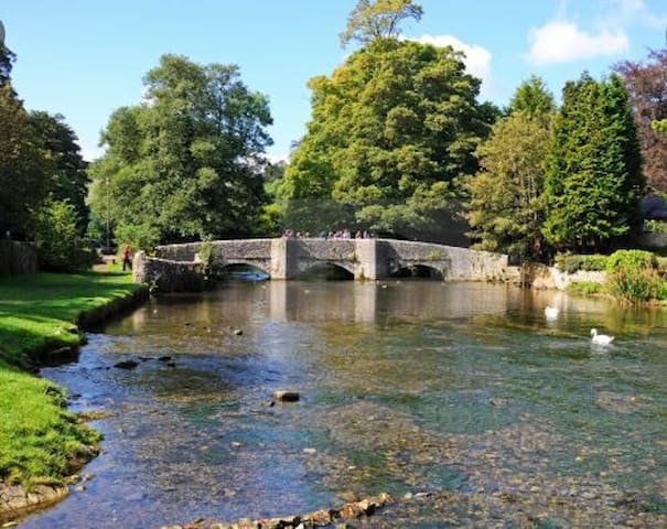
Ashford in the Water
Ashford in the Water is a very pretty, chocolate box village in the heart of the White Peak, visited by hundreds of thousands of tourists every year. It is home to the most photographed bridge in Britain, which has the gloriously crystal clear waters of the River Wye flowing free underneath. It's a tiny place and is made up of ancient picturesque cottages, two pubs, a stunning hotel with a riverside setting, a beautiful church, which houses relics dating back to the 1200s and a village store and delicatessen, who boasts they have the best home-made pickles in Derbyshire. Home to the lucky few, the cottages were once owned by the Chatsworth estate. These were sold off in the 1950s to pay for death duties.
With the famous Sheep Wash Bridge adorning many a postcard and photograph, tourists flock to hear how sheep were washed in the water before chemical dips were introduced. Lambs were kept in the walled pen on the other side, which is still in good working order and used in demonstrations today, to entice their mothers to have their bath and swim to the other side. The bridge makes a great vantage point for watching the huge rainbow trout meandering leisurely on their way below your feet.
There are several places for the walker to rest their weary legs and enjoy refreshments. The tea rooms in Ashford have a new gift shop and offer delicious lunches, top quality coffees, a variety of local speciality teas and cold drinks and other light refreshments. The Ashford Arms, which was once a coaching inn, welcomes weary travellers since the 1700s, and the Riverside Hotel offers a chance to sit in the sunshine enjoying a beverage and listening to the River babbling by.
Ashford in the Water is really lovely place to stay and makes an ideal base for any holiday maker who enjoys a peaceful break. With the beautiful market town of Bakewell just a few miles away, and Monsal Dale with its famous viaduct and trail for bikers and walkers, this little village has something for all the family to see and do during your stay. Steeped in history, the cottages themselves add a flavour of times gone by. Ashford Church houses one of the finest examples of an inlaid tabletop and there are examples of pottery in Buxton museum now on show. Holy Trinity Parish Church is the heart of the pretty village, with garlands hung from ancient times, still visible from the rafters of the roof. Read about this ancient custom in our Ashford in the Water history page.
It is the village renowned and used by local industries in the past, with very diverse and different businesses, including lead mining and candle making. Testament to the latter is the Candle House, which stands proud on the site of the old candle making factory in Greaves Lane, named after the dregs of melted tallow. Ashford black marble has also put this village on the map when Henry Watson discovered it, a limestone that when polished, makes the perfect background to mosaic and inlaid patterns.
Ashford Well dressing week is one of the highlights of the village calendar, but a must for all visitors to the area. Tourists arrive in their coach loads to see examples of this ancient local custom. The stunning artwork is presented and dedicated to 6 wells dotted around the village and is lovingly created by the local community.
A great base for breath taking walks. Take a step back in time and meandering down Bradford Dale along the river to Youlgrave or Lathkill Dale - the choice is yours.
Alport is one of three such named places in Derbyshire, the others being Alport Heights between Wirksworth and Ambergate, and Alport Moor in the High Peak – which is also the source of the River Alport. What connects the three Alports and is responsible for the place name, is the ancient track known as the Portway. This ancient way pre-dates the Roman occupation and runs roughly south-east to north-west through the county. The Anglo-Saxons called it ‘Port-weg’ – ‘port’ meaning a market town, so the Portway was ‘the road to the market’. Sections of it were used by pack-horse teams right up to the end of the eighteenth century, and Alport (Auld-Port) was a significant staging post along this ancient trading route. The old pack horse bridge marks part of the original route of the Portway.
The village lies at the confluence of the rivers Lathkill and Bradford and that is perhaps the reason for its existence. Water power was a requirement for most early industry and there was a corn mill recorded at Alport in the 12th century.
From the 17th to late 19th centuries, Alport was a very different place to today. For a period of nigh on 300 years, this area was an important lead mining centre. The Alport Mining Company used no less than 6 water pressure engines (as invented by the great engineer Richard Trevithick) to prevent flooding in its mines. Today this clean and peaceful village is very different to how it was in the 19th century. The Cupola lead smelting works that was operating at that time produced large volumes of unfiltered toxic gases and other pollution. Cupolas superseded the original bole hill type of smelters in the 16th and 17th centuries. They had well developed flue systems leading to their chimneys. In the flues, lead condensed from the waste gases and could be collected by hand, maximising the output from the smelter. A grim job indeed and possibly more dangerous than the lead mining! The Alport Cupola is reputed to have been one of the best developed flue systems in the Peak District. Lead mining ceased in the area in the mid 1800s and smelting followed suite in the 1890s.
Traces of Alport’s heritage remain as testimony to its industrial past; the magnificent 18th century corn mill, which featured in the film version of DH Lawrence’s ‘The Virgin & the Gypsy’, still stands in its beautiful setting on the east bank of the river by the weir. Also on this side are ‘Bank House’ and the pretty ‘Brook Cottage’. Close by, relics of the lead-smelter still survive, though the crumbling chimneys flues are overgrown with dense vegetation.
If you are a walker and wish to follow one of the footpaths from Alport, there is a little parking on the Youlgrave road in two roughly surfaced bays either side. Please park sensibly. From the Bridge, you can take the footpath north and explore Lathkill Dale. From the other side of the bridge, the track takes you up Bradford Dale, bringing you out at Youlgrave.
The village’s oldest dwelling is the ancient twin-gabled ‘Monks Hall’, with east and west wings and a central pediment.
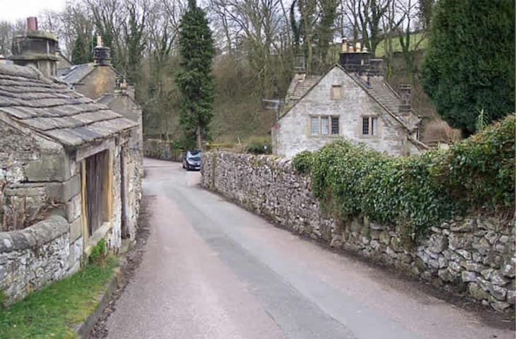
Alport
A great base for breath taking walks. Take a step back in time and meandering down Bradford Dale along the river to Youlgrave or Lathkill Dale - the choice is yours.
Alport is one of three such named places in Derbyshire, the others being Alport Heights between Wirksworth and Ambergate, and Alport Moor in the High Peak – which is also the source of the River Alport. What connects the three Alports and is responsible for the place name, is the ancient track known as the Portway. This ancient way pre-dates the Roman occupation and runs roughly south-east to north-west through the county. The Anglo-Saxons called it ‘Port-weg’ – ‘port’ meaning a market town, so the Portway was ‘the road to the market’. Sections of it were used by pack-horse teams right up to the end of the eighteenth century, and Alport (Auld-Port) was a significant staging post along this ancient trading route. The old pack horse bridge marks part of the original route of the Portway.
The village lies at the confluence of the rivers Lathkill and Bradford and that is perhaps the reason for its existence. Water power was a requirement for most early industry and there was a corn mill recorded at Alport in the 12th century.
From the 17th to late 19th centuries, Alport was a very different place to today. For a period of nigh on 300 years, this area was an important lead mining centre. The Alport Mining Company used no less than 6 water pressure engines (as invented by the great engineer Richard Trevithick) to prevent flooding in its mines. Today this clean and peaceful village is very different to how it was in the 19th century. The Cupola lead smelting works that was operating at that time produced large volumes of unfiltered toxic gases and other pollution. Cupolas superseded the original bole hill type of smelters in the 16th and 17th centuries. They had well developed flue systems leading to their chimneys. In the flues, lead condensed from the waste gases and could be collected by hand, maximising the output from the smelter. A grim job indeed and possibly more dangerous than the lead mining! The Alport Cupola is reputed to have been one of the best developed flue systems in the Peak District. Lead mining ceased in the area in the mid 1800s and smelting followed suite in the 1890s.
Traces of Alport’s heritage remain as testimony to its industrial past; the magnificent 18th century corn mill, which featured in the film version of DH Lawrence’s ‘The Virgin & the Gypsy’, still stands in its beautiful setting on the east bank of the river by the weir. Also on this side are ‘Bank House’ and the pretty ‘Brook Cottage’. Close by, relics of the lead-smelter still survive, though the crumbling chimneys flues are overgrown with dense vegetation.
If you are a walker and wish to follow one of the footpaths from Alport, there is a little parking on the Youlgrave road in two roughly surfaced bays either side. Please park sensibly. From the Bridge, you can take the footpath north and explore Lathkill Dale. From the other side of the bridge, the track takes you up Bradford Dale, bringing you out at Youlgrave.
The village’s oldest dwelling is the ancient twin-gabled ‘Monks Hall’, with east and west wings and a central pediment.
Food scene
Astonefield is an absolute must when visiting the Manifold Valley or Ilam Country Park. A lovely village with a wonderful pub overlooking the village green.
Alstonefield is a predominantly farming community as here there are undulating fields of rich pasture enclosed by typical drystone walls constructed of local limestone.
Alstonefield was at the centre of a vast Parish some 150 years ago. Although now greatly reduced in size, the Parish of Alstonefield still extends to include the hamlets of Milldale, Hope and Stanshope.
The name Alstonefield is said to derive from Aelfstan’s Feld which translates roughly to ‘tract of open land’. The village lies at a junction of many ancient paths and packhorse routes including Millway Lane which comes up the hill from the picturesque hamlet of Milldale. Izaak Walton is said to have travelled this route before descending Narrowdale on his visit to Berresford Hall and his friend Charles Cotton. On reaching Alstonefield church he is said to have remarked: “As I’m an honest man, a very pretty church”.
The path down Narrowdale was originally the main route from Alstonefield to Hartington. Other lovely tracks from the village include Gypsy Bank where a path leads down to the River Dove downstream of Wolfscote Dale. A deed of 1687 actually refers to this track from Alstonefield as leading to Bakewell. Land here was given by a local man named Bowman for use as a Quaker burial ground, and a barn along the lane here is still known as Bowman’s Barn.
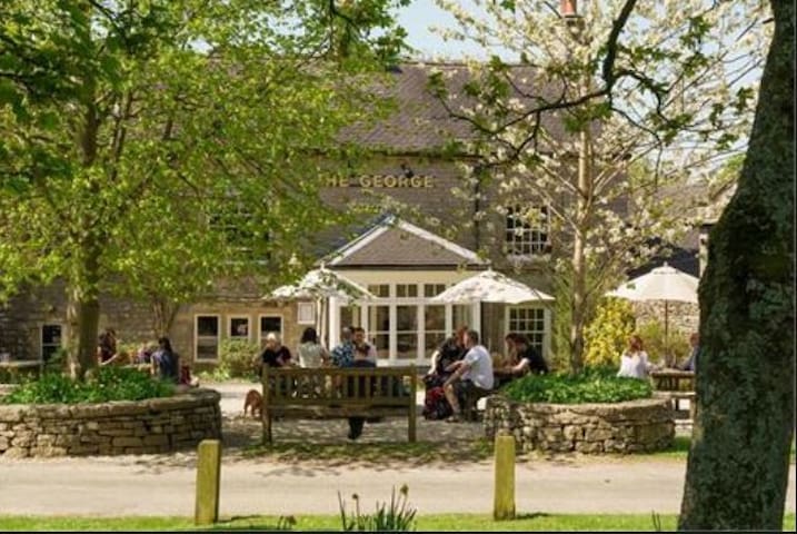
Alstonefield has a small village green where a local market was held from 1308 to around 1500. Annual cattle sales were also held in the yard of the George Inn until early in the 20th century.
Along the road from the village green, passing the former rectory and manor house which is dated 1587 above the porch, is St Peter’s Church which contains interesting features including early box pews that contain original brasswork. Here you can find the Cotton family pew which was sadly painted green by a former vicar in the 19th century. There is also a two-decker pulpit of 1637. In the churchyard are fragments of a 10th century cross shaft with interlace decoration along with one of the earliest recorded gravestones dated 3rd April 1518 and belonging to Anne Green.
There have been three churches on the same site at Alstonefield, the earliest being built about 892. The oldest surviving parts of the present church are probably the Norman south doorway and chancel arch which date from around 1100.
Alstonefield is surrounded by a network of wonderful paths and tracks making it an extremely popular area for walkers. With its close proximity to Dove Dale as well as the Manifold Way and Ilam Country Park, there are some fabulous walks and cycle paths to be explored.
Alstonefield
Astonefield is an absolute must when visiting the Manifold Valley or Ilam Country Park. A lovely village with a wonderful pub overlooking the village green.
Alstonefield is a predominantly farming community as here there are undulating fields of rich pasture enclosed by typical drystone walls constructed of local limestone.
Alstonefield was at the centre of a vast Parish some 150 years ago. Although now greatly reduced in size, the Parish of Alstonefield still extends to include the hamlets of Milldale, Hope and Stanshope.
The name Alstonefield is said to derive from Aelfstan’s Feld which translates roughly to ‘tract of open land’. The village lies at a junction of many ancient paths and packhorse routes including Millway Lane which comes up the hill from the picturesque hamlet of Milldale. Izaak Walton is said to have travelled this route before descending Narrowdale on his visit to Berresford Hall and his friend Charles Cotton. On reaching Alstonefield church he is said to have remarked: “As I’m an honest man, a very pretty church”.
The path down Narrowdale was originally the main route from Alstonefield to Hartington. Other lovely tracks from the village include Gypsy Bank where a path leads down to the River Dove downstream of Wolfscote Dale. A deed of 1687 actually refers to this track from Alstonefield as leading to Bakewell. Land here was given by a local man named Bowman for use as a Quaker burial ground, and a barn along the lane here is still known as Bowman’s Barn.
Alstonefield has a small village green where a local market was held from 1308 to around 1500. Annual cattle sales were also held in the yard of the George Inn until early in the 20th century.
Along the road from the village green, passing the former rectory and manor house which is dated 1587 above the porch, is St Peter’s Church which contains interesting features including early box pews that contain original brasswork. Here you can find the Cotton family pew which was sadly painted green by a former vicar in the 19th century. There is also a two-decker pulpit of 1637. In the churchyard are fragments of a 10th century cross shaft with interlace decoration along with one of the earliest recorded gravestones dated 3rd April 1518 and belonging to Anne Green.
There have been three churches on the same site at Alstonefield, the earliest being built about 892. The oldest surviving parts of the present church are probably the Norman south doorway and chancel arch which date from around 1100.
Alstonefield is surrounded by a network of wonderful paths and tracks making it an extremely popular area for walkers. With its close proximity to Dove Dale as well as the Manifold Way and Ilam Country Park, there are some fabulous walks and cycle paths to be explored.