
Guidebook for Marysville
Food Scene
Run by chefs from Melbourne
Pasta & Pizza & some rice dishes
Licensed
12 ντόπιοι το προτείνουν
Elevation 423
43 Murchison StRun by chefs from Melbourne
Pasta & Pizza & some rice dishes
Licensed
Fraga's is closed for the month of February for a well deserved annual break.
Good coffee, nice lunch menu with an assortment of baguettes, soups & pastries. Great outdoor seating area overlooking Murchison Street (main street).
21 ντόπιοι το προτείνουν
Fraga's Cafe
19 Murchison StFraga's is closed for the month of February for a well deserved annual break.
Good coffee, nice lunch menu with an assortment of baguettes, soups & pastries. Great outdoor seating area overlooking Murchison Street (main street).
Located opposite the Marysville Golf course.
Offering home cooked Australian and Asian cuisine.
A La Carte, kids, Asian and take-away menu available.
Served in the upper room restaurant.
Available for breakfast, lunch, morning & afternoon tea & dinner.
Bookings essential!
BYO, No corkage
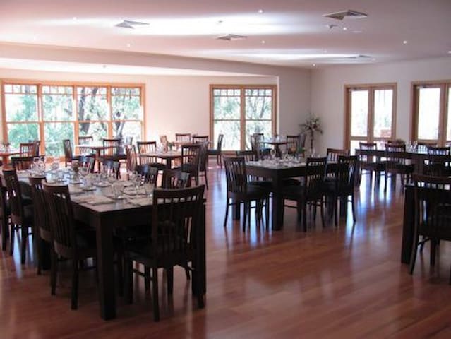
EL Kanah Marysville
975 Buxton-Marysville RdLocated opposite the Marysville Golf course.
Offering home cooked Australian and Asian cuisine.
A La Carte, kids, Asian and take-away menu available.
Served in the upper room restaurant.
Available for breakfast, lunch, morning & afternoon tea & dinner.
Bookings essential!
BYO, No corkage
Located on a prominent corner on Murchison Street.
Large bakery with indoor and outdoor seating.
Serving sandwiches, pies, pastries, burgers, coffee, tea and soft drinks. Generous portions.
9 ντόπιοι το προτείνουν
Marysville Country Bakery
17 Murchison StLocated on a prominent corner on Murchison Street.
Large bakery with indoor and outdoor seating.
Serving sandwiches, pies, pastries, burgers, coffee, tea and soft drinks. Generous portions.
Located in Peppers Conference centre on the main road. Feedback is mixed in regards to the food and staff.
Bit pricey.
8 ντόπιοι το προτείνουν
Radius Bar & Grill
32-34 Murchison StLocated in Peppers Conference centre on the main road. Feedback is mixed in regards to the food and staff.
Bit pricey.
Like many country supermarkets it is well stocked with fresh vegetables, bread, meat, dairy, spices, newspapers, alcohol, hardware needs etc. The larger sister store operated by the same family is in Alexandra. Open daily except Christmas day from 7AM till 6PM
10 ντόπιοι το προτείνουν
FoodWorks Marysville
49A Darwin StLike many country supermarkets it is well stocked with fresh vegetables, bread, meat, dairy, spices, newspapers, alcohol, hardware needs etc. The larger sister store operated by the same family is in Alexandra. Open daily except Christmas day from 7AM till 6PM
A relative new café at the beginning of the main street (Murchison near the round about).
Great coffee, cakes, lunches, juices
Indoor and outdoor areas
Take-away
6 ντόπιοι το προτείνουν
Keppel Cafe Marysville
45 Murchison StA relative new café at the beginning of the main street (Murchison near the round about).
Great coffee, cakes, lunches, juices
Indoor and outdoor areas
Take-away
Parks & Nature
Winter: Tobogganing & cross country skiiing
Summer: Hiking and mountain biking
Handy websites for hikes in the area:
https://www.trailhiking.com.au/keppell-lookout-and-steavenson-falls/
Right behind the Marysville information centre.
Great adventure park, with swings, dinosaur discovery sand pit, sculptures, water and sand play, beautiful garden setting, barbecues and sheltered seating, public toilets. Connected to the lake, which has a flying fox next to it and a wonderful walking path, ducks, fountain.
Gallipoli Park
Gallipoli ParkRight behind the Marysville information centre.
Great adventure park, with swings, dinosaur discovery sand pit, sculptures, water and sand play, beautiful garden setting, barbecues and sheltered seating, public toilets. Connected to the lake, which has a flying fox next to it and a wonderful walking path, ducks, fountain.
Picnic area accessible from Falls Road via walking track or via the Tree Fern Gully Track which starts behind the oval on the other side of the steavenson's river.
Yellow Dog Road
Yellow Dog RoadPicnic area accessible from Falls Road via walking track or via the Tree Fern Gully Track which starts behind the oval on the other side of the steavenson's river.
The Tree Fern Gully Track takes you to Steavenson Falls – 8km, 2 hrs
Walk amongst the tall tree ferns and luxuriant vegetation along the Steavenson River. Follow the track upstream, over the bridge and across Yellow Dog Road. Continue on to the spectacular Steavenson Falls. The Falls drop 82m in three stages into the steep-sided river valley. To return, simply retrace your steps along Tree Fern Gully Track.
Tree Fern Gully Track
Treefern Gully TrackThe Tree Fern Gully Track takes you to Steavenson Falls – 8km, 2 hrs
Walk amongst the tall tree ferns and luxuriant vegetation along the Steavenson River. Follow the track upstream, over the bridge and across Yellow Dog Road. Continue on to the spectacular Steavenson Falls. The Falls drop 82m in three stages into the steep-sided river valley. To return, simply retrace your steps along Tree Fern Gully Track.
Michaeldene Track – 9km, 3 hrs
The walk to the picturesque Island Hop begins at the junction of Marysville-Woods Point Road and Lady Talbot Drive or walk to the start of the Tree Fern Gully Walk and follow the signs from there. Follow the Michaeldene Track to the Wishing Well, a natural spring which has long been a popular attraction. About 400m further on, at the junction with the Trestle Track, lies an historic trestle bridge. As you continue on to the Taggerty River, keep an eye out for trout swimming between the rocks as you cross between the river islands to the other side. There is a choice for your return to Marysville. Either retrace your steps or at the Trestle Track junction, head west (right) and a little way along turn south (left) along Manfern Track. This will lead you back to where you began your journey.
Michaeldene Track
Michaeldene TrackMichaeldene Track – 9km, 3 hrs
The walk to the picturesque Island Hop begins at the junction of Marysville-Woods Point Road and Lady Talbot Drive or walk to the start of the Tree Fern Gully Walk and follow the signs from there. Follow the Michaeldene Track to the Wishing Well, a natural spring which has long been a popular attraction. About 400m further on, at the junction with the Trestle Track, lies an historic trestle bridge. As you continue on to the Taggerty River, keep an eye out for trout swimming between the rocks as you cross between the river islands to the other side. There is a choice for your return to Marysville. Either retrace your steps or at the Trestle Track junction, head west (right) and a little way along turn south (left) along Manfern Track. This will lead you back to where you began your journey.
Climb up through stringybark and mountain ash forest to four of Marysville's best lookouts for spectacular views across Marysville, the Cathedral Range State Park and Steavenson Falls.
The most challenging trail in the area, the Keppel Lookout Trail is fairly uneven and steep in places. Wear sturdy footwear and carry water and snacks.
Start the trail from the car park on Falls Road. Follow the trail across Robertson Gully before climbing up to Keppel Lookout, around the ridge passing Oxlee and De La Rue lookouts, and to the top of Steavenson Falls. Descend to the base of Steavenson Falls and follow the Tree Fern Gully Trail.
Distance: 11km loop
Duration: 3–4 hours
Grade: Level 3; very steep, formed track
Start: Car park on Falls Road
Finish: Car park on Falls Road
Nearby: Marysville
Note: Bicycles and horses not permitted.
Note: the car park on Falls Road can also be accessed by walking two kilometres along the Tree Fern Gully Trail from Marysville.
Keppel Lookout Trail
Falls RoadClimb up through stringybark and mountain ash forest to four of Marysville's best lookouts for spectacular views across Marysville, the Cathedral Range State Park and Steavenson Falls.
The most challenging trail in the area, the Keppel Lookout Trail is fairly uneven and steep in places. Wear sturdy footwear and carry water and snacks.
Start the trail from the car park on Falls Road. Follow the trail across Robertson Gully before climbing up to Keppel Lookout, around the ridge passing Oxlee and De La Rue lookouts, and to the top of Steavenson Falls. Descend to the base of Steavenson Falls and follow the Tree Fern Gully Trail.
Distance: 11km loop
Duration: 3–4 hours
Grade: Level 3; very steep, formed track
Start: Car park on Falls Road
Finish: Car park on Falls Road
Nearby: Marysville
Note: Bicycles and horses not permitted.
Note: the car park on Falls Road can also be accessed by walking two kilometres along the Tree Fern Gully Trail from Marysville.
Spot beautiful flora and fauna on one of Marysville's most-loved short walks. This easy nature trail follows the winding Leary Creek deep into tree fern groves and features a number of interpretive signs. The trail's abundant bird life will delight ornithologists, particularly at dawn and dusk.
There are two possible circuits: one short (0.5 kilometres), one longer (1.5 kilometres). For both circuits, start from the car park and follow the trail into the fern-filled gully. At the major intersection veer left and follow the trail along to the next junction.
For the shorter circuit, head right and follow the path as it crosses Leary Creek twice before arriving back at the car park. For the longer circuit, continue left from the junction and deeper into the gully before rejoining the shorter loop and returning to the car park.
Location: Marysville
Distance: Option of 0.5km or 1.5km loop
Duration: 10–40 minutes
Grade: Level 2
Start/Finish: Beauty Spot car park
Note: Bicycles and pets not permitted.
Beauty Spot Walking Track
Beauty Spot Walking TrackSpot beautiful flora and fauna on one of Marysville's most-loved short walks. This easy nature trail follows the winding Leary Creek deep into tree fern groves and features a number of interpretive signs. The trail's abundant bird life will delight ornithologists, particularly at dawn and dusk.
There are two possible circuits: one short (0.5 kilometres), one longer (1.5 kilometres). For both circuits, start from the car park and follow the trail into the fern-filled gully. At the major intersection veer left and follow the trail along to the next junction.
For the shorter circuit, head right and follow the path as it crosses Leary Creek twice before arriving back at the car park. For the longer circuit, continue left from the junction and deeper into the gully before rejoining the shorter loop and returning to the car park.
Location: Marysville
Distance: Option of 0.5km or 1.5km loop
Duration: 10–40 minutes
Grade: Level 2
Start/Finish: Beauty Spot car park
Note: Bicycles and pets not permitted.
Walk among the tallest flowering trees in the world. This breathtaking walk passes through rare mature-aged mountain ash to the majestic, 85-metre Big Tree, which has been towering above the forest floor for some 400 years.
Find the Cora Lynn and Cumberland waterfalls in a rainforest gully and take in sweeping views of the Cumberland Valley from Sovereign View.
Start this circuit walk at the Cambarville car park, just off the Marysville-Woods Point Road. Pass beneath the Big Tree and the Sitka Spruce to reach the Marysville-Woods Point Road. Cross over the road and continue along the trail to Cora Lynn Falls then to Cumberland Falls. Follow the trail to nearby Sovereign View, cross the road and finish back at the car park.
Location: Yarra Ranges National Park
Distance: 4km
Duration: 2 hours
Grade: Level 3; short steep hills, formed track, some obstacles
Start: Cambarville picnic area car park
Finish: Cambarville picnic area car park
Nearby: Cambarville
Note: Bicycles, motorbikes, horses and pets not permitted.
Cumberland Junction
Warburton-Woods Point RoadWalk among the tallest flowering trees in the world. This breathtaking walk passes through rare mature-aged mountain ash to the majestic, 85-metre Big Tree, which has been towering above the forest floor for some 400 years.
Find the Cora Lynn and Cumberland waterfalls in a rainforest gully and take in sweeping views of the Cumberland Valley from Sovereign View.
Start this circuit walk at the Cambarville car park, just off the Marysville-Woods Point Road. Pass beneath the Big Tree and the Sitka Spruce to reach the Marysville-Woods Point Road. Cross over the road and continue along the trail to Cora Lynn Falls then to Cumberland Falls. Follow the trail to nearby Sovereign View, cross the road and finish back at the car park.
Location: Yarra Ranges National Park
Distance: 4km
Duration: 2 hours
Grade: Level 3; short steep hills, formed track, some obstacles
Start: Cambarville picnic area car park
Finish: Cambarville picnic area car park
Nearby: Cambarville
Note: Bicycles, motorbikes, horses and pets not permitted.
Hear the Taggerty River thunder over boulders and overhanging ferns as you follow this short, winding, stepped path to a wooden bridge spanning the river. Keep a close eye out for lyrebirds scratching for grubs in the undergrowth.
From the Taggerty Cascades car park on Lady Talbot Drive, take the steps down to the bridge. Return the same way.
This trail is part of the Beeches Rainforest Walk.
Location: Yarra Ranges National Park
Distance: 150m
Duration: 20 minutes
Grade: Level 2; short steep hills, formed track, some obstacles
Start/Finish: Taggerty Cascades car park
Nearby: Marysville
Note: Bicycles, motorbikes, horses and pets not permitted.
Taggerty River Cascades
Hear the Taggerty River thunder over boulders and overhanging ferns as you follow this short, winding, stepped path to a wooden bridge spanning the river. Keep a close eye out for lyrebirds scratching for grubs in the undergrowth.
From the Taggerty Cascades car park on Lady Talbot Drive, take the steps down to the bridge. Return the same way.
This trail is part of the Beeches Rainforest Walk.
Location: Yarra Ranges National Park
Distance: 150m
Duration: 20 minutes
Grade: Level 2; short steep hills, formed track, some obstacles
Start/Finish: Taggerty Cascades car park
Nearby: Marysville
Note: Bicycles, motorbikes, horses and pets not permitted.
Lake Mountain Summit Walk
Take in landscapes of snowgums and alpine heath, plus panoramic views of the Victorian Alps across to Melbourne and the Great Dividing Range from the Yarra Ranges National Park.
In snow season (June to September) mountain and trail entry fees apply. Contact Lake Mountain Alpine Resort for more information.
Follow the wide track as it climbs steeply for 200 metres before levelling out to a gentle incline to the summit. The track to Marysville lookout takes off to the west from just below the summit. From the summit the walk heads east to the Alps Lookout. From here it passes through an alpine bog and over several granite rock faces covered with lichens and mosses to reach the junction with the Snowy Hill track. Sherlocks lookout is located 100 metres along the Snowy track. Returning to the junction, the walk continues to Taggerty Valley View and then to Gerraty's car park via the summit.
You can also take the shorter walk of 40 minutes from Gerraty's car park to the summit, and a more challenging route starting from Snowy Hill car park.
The terrain is rocky in places and sturdy footwear is recommended. Alpine weather conditions are subject to change. Please dress appropriately.
Distance: 4km return
Duration: 2 hours at a leisurely pace
Track condition: Medium
Grade: Moderately steep
Start: Village car park
Finish: Village car park
Nearby: Marysville
Permits/bookings: Snow season fees apply. None required other times.
9 ντόπιοι το προτείνουν
Lake Mountain
Lake Mountain Summit Walk
Take in landscapes of snowgums and alpine heath, plus panoramic views of the Victorian Alps across to Melbourne and the Great Dividing Range from the Yarra Ranges National Park.
In snow season (June to September) mountain and trail entry fees apply. Contact Lake Mountain Alpine Resort for more information.
Follow the wide track as it climbs steeply for 200 metres before levelling out to a gentle incline to the summit. The track to Marysville lookout takes off to the west from just below the summit. From the summit the walk heads east to the Alps Lookout. From here it passes through an alpine bog and over several granite rock faces covered with lichens and mosses to reach the junction with the Snowy Hill track. Sherlocks lookout is located 100 metres along the Snowy track. Returning to the junction, the walk continues to Taggerty Valley View and then to Gerraty's car park via the summit.
You can also take the shorter walk of 40 minutes from Gerraty's car park to the summit, and a more challenging route starting from Snowy Hill car park.
The terrain is rocky in places and sturdy footwear is recommended. Alpine weather conditions are subject to change. Please dress appropriately.
Distance: 4km return
Duration: 2 hours at a leisurely pace
Track condition: Medium
Grade: Moderately steep
Start: Village car park
Finish: Village car park
Nearby: Marysville
Permits/bookings: Snow season fees apply. None required other times.
Walking, Hiking & Horseriding.
At 5330 kilometres, stretching from Healesville to Cooktown in far north Queensland, this is the longest trail of its kind in the world. Following historic coach and stock routes and old packhorse trails along much of its length, it's a journey of dramatic extremes, from tropical rainforests to alpine snowfields, from remote dry plains to rugged mountains and steep gorges.
From the town of Healesville, only 60 kilometres north-east of Melbourne, it's a ride through a rich and varied landscape, featuring dense forests, deep river valleys, alpine peaks and plains, as well as the sites of old gold towns and pioneer settlements Wonnangatta Valley and Howitt Plains.
Beyond Omeo the trail enters very remote and rugged areas in the north-east part of the Alpine National Park, crossing the Australian Alps Walking Track near the Cobberas, just south of the NSW border.
Riders should be experienced in the use of navigational aids and prepared for sudden adverse weather changes. Some sections of the trail are also suitable for walkers and mountain bike riders.
Note: within the Alpine National Park there are limits on numbers of horses and times of year when riding is permitted. Permits are also required for groups with more than five horses.
Below the link to the official website:
http://www.bicentennialnationaltrail.com.au/
Via the link below you can see the trail from Healesville to Marysville:
http://www.everytrail.com/view_trip.php?trip_id=1102387
Location: Alpine National Park
Length: 550km (to NSW border)
Track: Rough
Grade: Steep
Start: Healesville
Finish: NSW Border
Best time: Late Spring, autumn.
Bicentennial National Trail
Bicentennial National TrailWalking, Hiking & Horseriding.
At 5330 kilometres, stretching from Healesville to Cooktown in far north Queensland, this is the longest trail of its kind in the world. Following historic coach and stock routes and old packhorse trails along much of its length, it's a journey of dramatic extremes, from tropical rainforests to alpine snowfields, from remote dry plains to rugged mountains and steep gorges.
From the town of Healesville, only 60 kilometres north-east of Melbourne, it's a ride through a rich and varied landscape, featuring dense forests, deep river valleys, alpine peaks and plains, as well as the sites of old gold towns and pioneer settlements Wonnangatta Valley and Howitt Plains.
Beyond Omeo the trail enters very remote and rugged areas in the north-east part of the Alpine National Park, crossing the Australian Alps Walking Track near the Cobberas, just south of the NSW border.
Riders should be experienced in the use of navigational aids and prepared for sudden adverse weather changes. Some sections of the trail are also suitable for walkers and mountain bike riders.
Note: within the Alpine National Park there are limits on numbers of horses and times of year when riding is permitted. Permits are also required for groups with more than five horses.
Below the link to the official website:
http://www.bicentennialnationaltrail.com.au/
Via the link below you can see the trail from Healesville to Marysville:
http://www.everytrail.com/view_trip.php?trip_id=1102387
Location: Alpine National Park
Length: 550km (to NSW border)
Track: Rough
Grade: Steep
Start: Healesville
Finish: NSW Border
Best time: Late Spring, autumn.
Take an easy stroll to one of Victoria's highest waterfalls. Dropping 84 metres into the Steavenson River valley, the spectacular Steavenson Falls have been popular with tourists since the 1860s.
This 700-metre (return) walk leads to the viewing platform below the falls. (Energy enthusiasts, stop at the turbine generator along the way.) Visit day or night – the path and falls are floodlit between dusk and midnight.
Location: Steavenson Falls Reserve
Distance: 700m
Duration: 15-30 minutes
Grade: Level 1; flat, well formed track
Start: Steavenson Falls Reserve car park
Finish: Steavenson Falls Reserve car park
Nearby: Marysville
Note: Bicycles and pets not permitted.
21 ντόπιοι το προτείνουν
Καταρράκτες Στίβενσον
Falls RoadTake an easy stroll to one of Victoria's highest waterfalls. Dropping 84 metres into the Steavenson River valley, the spectacular Steavenson Falls have been popular with tourists since the 1860s.
This 700-metre (return) walk leads to the viewing platform below the falls. (Energy enthusiasts, stop at the turbine generator along the way.) Visit day or night – the path and falls are floodlit between dusk and midnight.
Location: Steavenson Falls Reserve
Distance: 700m
Duration: 15-30 minutes
Grade: Level 1; flat, well formed track
Start: Steavenson Falls Reserve car park
Finish: Steavenson Falls Reserve car park
Nearby: Marysville
Note: Bicycles and pets not permitted.
Rubicon Historic Area - Rubicon
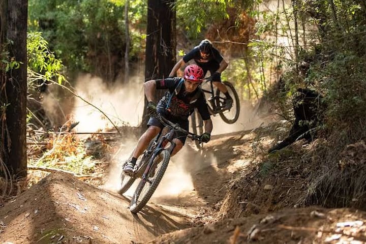
Walking and mountain bike riding
Park at the Boys Campsite and cycle West towards Camp Jungai. The Cicada Links Trail is about 6.1 kilometers round trip and is quite an easy trail ride. Little bit of elevation, but no jumps.
Just be mindful of fallen branches and trees.
More details about the Rubicon historic area in the file below:
https://www.ffm.vic.gov.au/__data/assets/pdf_file/0026/26396/FS0067-Rubicon-Camping-Areas.pdf
Buxton Mountain Bike Park is situated within the Black Range State forest, approximately 11 kms north
of Marysville. There is around
23 km of purpose built mountain bike single track in the park that can be ridden in a number of different length loops. The trails are ridden in one direction and are signed accordingly. The trails are characterised by gentle climbs and fast flowing descents. When ridden with care, the majority of trails are suitable for riders of all abilities, but when ridden faster, the tracks are
more challenging.
Location and Access
From Marysville, follow the Buxton-Marysville road and turn left onto the Maroondah Highway in Buxton. Turn right into Dyes Lane and follow the road for approximately
1 km. Cross the Acheron River and turn right to reach the trailhead and day visitor car park. All trails are closed during the wetter months each year from the Tuesday after Queens Birthday weekend in June and re
-open at the beginning of the September / October school holidays. This is to protect the track surface from erosion.
There are 9 different mountain bike trails that can be combined .
ils
The trails are graded based on International Mountain Bicycling Association (IMBA) standards. Trails
6 ντόπιοι το προτείνουν
Buxton MTB park
Mill Creek RoadBuxton Mountain Bike Park is situated within the Black Range State forest, approximately 11 kms north
of Marysville. There is around
23 km of purpose built mountain bike single track in the park that can be ridden in a number of different length loops. The trails are ridden in one direction and are signed accordingly. The trails are characterised by gentle climbs and fast flowing descents. When ridden with care, the majority of trails are suitable for riders of all abilities, but when ridden faster, the tracks are
more challenging.
Location and Access
From Marysville, follow the Buxton-Marysville road and turn left onto the Maroondah Highway in Buxton. Turn right into Dyes Lane and follow the road for approximately
1 km. Cross the Acheron River and turn right to reach the trailhead and day visitor car park. All trails are closed during the wetter months each year from the Tuesday after Queens Birthday weekend in June and re
-open at the beginning of the September / October school holidays. This is to protect the track surface from erosion.
There are 9 different mountain bike trails that can be combined .
ils
The trails are graded based on International Mountain Bicycling Association (IMBA) standards. Trails
Walk or cycle along the railway line that was built in 1901 to carry produce from Warburton to Melbourne and delivered tourists to the area on the return trip.
Choose between a series of short walks or an exciting trail ride, and look out for kangaroos, bird life and spring wildflowers between Lilydale and Mt Evelyn, and butterflies and tree ferns on the way to Wandin.
Stop off at the old railway station at Yarra Junction, now a pioneer museum, before taking in the magnificent views of the Central Highlands and Yarra Ranges National Park along the section to Wesburn. Relax at the Sam Knott Hotel (licensed 1863) at Wesburn before setting off on the final five-kilometre stretch to Warburton, a popular retreat and the end of the trail.
Pass through beautiful bush, lush fern gullies, sweeping grazing properties on the fertile Yarra River flood plains, past wineries, flower farms, the Yarra River and the Yarra Ranges National Park and state forest.
Take time to enjoy the spectacular views of the Dandenong and Yarra Ranges, the beauty of the Yarra River and the surrounding bush.
Distance: 38km one way
Duration: 3 hours (by bike)
Track condition: Good
Grade: Flat
Start: Queen Road, Lilydale
Finish: Warburton Water Wheel and Visitor Centre
Nearby: Lilydale
Permits/bookings: None required
34 ντόπιοι το προτείνουν
Warburton Trail
13 Mattea CtWalk or cycle along the railway line that was built in 1901 to carry produce from Warburton to Melbourne and delivered tourists to the area on the return trip.
Choose between a series of short walks or an exciting trail ride, and look out for kangaroos, bird life and spring wildflowers between Lilydale and Mt Evelyn, and butterflies and tree ferns on the way to Wandin.
Stop off at the old railway station at Yarra Junction, now a pioneer museum, before taking in the magnificent views of the Central Highlands and Yarra Ranges National Park along the section to Wesburn. Relax at the Sam Knott Hotel (licensed 1863) at Wesburn before setting off on the final five-kilometre stretch to Warburton, a popular retreat and the end of the trail.
Pass through beautiful bush, lush fern gullies, sweeping grazing properties on the fertile Yarra River flood plains, past wineries, flower farms, the Yarra River and the Yarra Ranges National Park and state forest.
Take time to enjoy the spectacular views of the Dandenong and Yarra Ranges, the beauty of the Yarra River and the surrounding bush.
Distance: 38km one way
Duration: 3 hours (by bike)
Track condition: Good
Grade: Flat
Start: Queen Road, Lilydale
Finish: Warburton Water Wheel and Visitor Centre
Nearby: Lilydale
Permits/bookings: None required
The Golf Course boasts one of Victoria’s most scenic golfing locations. While away a few hours with the relaxing sounds of the Steavenson River in the background.
Book a TEE time:
http://marysville.quick18.com/teetimes/searchmatrix
Tee times are available up to 14 days in advance. You may book for up to 8 players via the website.
Marysville golf course is open 7 days a week from dawn until dusk. Non-members are welcome at any time.
Golf Shop is open Saturday to Monday 8.00a.m. - 1.00p.m. Other days by prearrangement.
For larger group bookings or special requirements, please contact the club on (03) 5963 3241 or send an email to enquiries@marysvillegolfandbowls.com.au
8 ντόπιοι το προτείνουν
Marysville Golf Club
956 Buxton-Marysville RdThe Golf Course boasts one of Victoria’s most scenic golfing locations. While away a few hours with the relaxing sounds of the Steavenson River in the background.
Book a TEE time:
http://marysville.quick18.com/teetimes/searchmatrix
Tee times are available up to 14 days in advance. You may book for up to 8 players via the website.
Marysville golf course is open 7 days a week from dawn until dusk. Non-members are welcome at any time.
Golf Shop is open Saturday to Monday 8.00a.m. - 1.00p.m. Other days by prearrangement.
For larger group bookings or special requirements, please contact the club on (03) 5963 3241 or send an email to enquiries@marysvillegolfandbowls.com.au
2118 Maroondah Hwy, Buxton VIC 3711
Phone: (03) 5774 7370
Great place to enjoy fishing with the family and BBQ your catch. Welcomes everybody to come fishing at the Farm - Young or old, experienced or beginner, we guarantee a catch! Australia's first trout farm and a perfect day trip.
BBQ facilities at no extra cost, so you can cook your catch for lunch or take it home on ice.
Buxton Trout and Salmon Farm is Australia’s first trout farm where trout have been reared for over 50 years.
The gravity fed water supply originates from the snowfields of Lake Mountain before cascading down Stevensons Falls and through its streams providing the perfect place to grow a clean natural food. No antibiotic chemicals or growth hormones are used on our farm. The farm is a vertically integrated experience – we hatch the fish here and sell them ready for you to eat! Support local, sustainable and ethical food.
20 ντόπιοι το προτείνουν
Buxton Trout & Salmon
2118 Maroondah Hwy2118 Maroondah Hwy, Buxton VIC 3711
Phone: (03) 5774 7370
Great place to enjoy fishing with the family and BBQ your catch. Welcomes everybody to come fishing at the Farm - Young or old, experienced or beginner, we guarantee a catch! Australia's first trout farm and a perfect day trip.
BBQ facilities at no extra cost, so you can cook your catch for lunch or take it home on ice.
Buxton Trout and Salmon Farm is Australia’s first trout farm where trout have been reared for over 50 years.
The gravity fed water supply originates from the snowfields of Lake Mountain before cascading down Stevensons Falls and through its streams providing the perfect place to grow a clean natural food. No antibiotic chemicals or growth hormones are used on our farm. The farm is a vertically integrated experience – we hatch the fish here and sell them ready for you to eat! Support local, sustainable and ethical food.
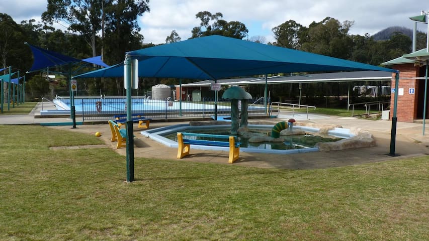
Marysville Outdoor Swimming Pool
Opens seasonally Early November - Queen's birthday weekend
Falls Road, Marysville 3779, Victoria, Australia.
Next to the primary school at the beginning of Falls Road.
Telephone: (03) 5963 3387
Opening hours:
During school term: Monday to Friday 3pm – 6pm .
During school holidays, weekends and public holidays:
1pm – 6pm (closed Christmas Day)
Pool will not be open on days forecast to be under 18 degrees.
Lap swimming – Monday, Wednesday and Friday – 7.30am to 9.30am.
Season tickets available.
See website for full range of prices.
The main pool which is 33m long and varies in depth from 1.4m to 3.0m plus an octagonal toddlers pool with worm and mushroom sprays which is 0.25m deep. Two-thirds of the toddler pool is shaded and there are three shaded seats beside the pool. One side of the main pool has a shelter for shade with tables and seats and the other side has three shade sails over the grass. In one corner is a small area of un-shaded lawn.
Falls Road
Falls RoadMarysville Outdoor Swimming Pool
Opens seasonally Early November - Queen's birthday weekend
Falls Road, Marysville 3779, Victoria, Australia.
Next to the primary school at the beginning of Falls Road.
Telephone: (03) 5963 3387
Opening hours:
During school term: Monday to Friday 3pm – 6pm .
During school holidays, weekends and public holidays:
1pm – 6pm (closed Christmas Day)
Pool will not be open on days forecast to be under 18 degrees.
Lap swimming – Monday, Wednesday and Friday – 7.30am to 9.30am.
Season tickets available.
See website for full range of prices.
The main pool which is 33m long and varies in depth from 1.4m to 3.0m plus an octagonal toddlers pool with worm and mushroom sprays which is 0.25m deep. Two-thirds of the toddler pool is shaded and there are three shaded seats beside the pool. One side of the main pool has a shelter for shade with tables and seats and the other side has three shade sails over the grass. In one corner is a small area of un-shaded lawn.
Blue Lotus Water Garden - fun for the whole family.
Photo's to follow
9 ντόπιοι το προτείνουν
Yarra Junction
Blue Lotus Water Garden - fun for the whole family.
Photo's to follow
Two mountain bike trails at Lake Mountain from beginners to advanced. One on top of the mountain and one which starts at the top and finishes in Marysville called Cascade Trail .
Mountain bike shuttles operate every weekend from Saturday 2nd of November till 8 March. Riders that pre-book are collected from Marysville at their booked time. Book through trybooking.com Pickup location at the car park outside the Marysville Caravan Park 1130 Buxton-Marysville road.
Mountain bikes and helmets can be rented.
9 ντόπιοι το προτείνουν
Lake Mountain
Two mountain bike trails at Lake Mountain from beginners to advanced. One on top of the mountain and one which starts at the top and finishes in Marysville called Cascade Trail .
Mountain bike shuttles operate every weekend from Saturday 2nd of November till 8 March. Riders that pre-book are collected from Marysville at their booked time. Book through trybooking.com Pickup location at the car park outside the Marysville Caravan Park 1130 Buxton-Marysville road.
Mountain bikes and helmets can be rented.
Great in winter for snow play, tobogganing, skiing.
Cafe and ski equipment hire at Lake Mountain.
The Village toboggan run is groomed throughout the snow season. Book a ticket for the car park before you head up the mountain as there are limitations on the number of visitors and sometimes they will close the access road until people leave the mountain.
For mountain bikers there is a single track mountain bike trail named Cascade Trail from the top of Lake Mountain all the way down to Marysville. A shuttle bus is available
Price: $30- Single Shuttle $55- Multiple shuttle rides
Booking a ticket:
All tickets must be pre-purchased online prior to your visit.
Only one ticket can be purchased at a time due to individual Covid-19 questions and requirements.
Shuttle check in and departure is located at Lake Mountain Visitor Centre (27 Murchison Street, Marysville), with parking available behind the building.
Please arrive at least 20 minutes prior to the departure time stated on the purchased ticket to ensure all necessary check in procedures are completed.
Once arrived, please enter the Lake Mountain Visitor Centre to complete the check-in process with our Lake Mountain team:
Please provide your name (as stated on the ticket), photo identification and evidence of being fully vaccinated
Please advise Lake Mountain Visitor Centre staff if you have purchased multiple shuttle ticket on the day, so that we can arrange your second or third pick-up
Please phone the Visitor Centre at (03) 5957 7209 with any questions or enquiries about our various bike hire options.
9 ντόπιοι το προτείνουν
Lake Mountain
Great in winter for snow play, tobogganing, skiing.
Cafe and ski equipment hire at Lake Mountain.
The Village toboggan run is groomed throughout the snow season. Book a ticket for the car park before you head up the mountain as there are limitations on the number of visitors and sometimes they will close the access road until people leave the mountain.
For mountain bikers there is a single track mountain bike trail named Cascade Trail from the top of Lake Mountain all the way down to Marysville. A shuttle bus is available
Price: $30- Single Shuttle $55- Multiple shuttle rides
Booking a ticket:
All tickets must be pre-purchased online prior to your visit.
Only one ticket can be purchased at a time due to individual Covid-19 questions and requirements.
Shuttle check in and departure is located at Lake Mountain Visitor Centre (27 Murchison Street, Marysville), with parking available behind the building.
Please arrive at least 20 minutes prior to the departure time stated on the purchased ticket to ensure all necessary check in procedures are completed.
Once arrived, please enter the Lake Mountain Visitor Centre to complete the check-in process with our Lake Mountain team:
Please provide your name (as stated on the ticket), photo identification and evidence of being fully vaccinated
Please advise Lake Mountain Visitor Centre staff if you have purchased multiple shuttle ticket on the day, so that we can arrange your second or third pick-up
Please phone the Visitor Centre at (03) 5957 7209 with any questions or enquiries about our various bike hire options.
Arts & Culture
The original and unique artworks of sculptor and painter Bruno Torfs continues to bring joy and inspiration to visitors from all over the world. Nestled amongst the luscious rainforest setting lives a collection of unforgettable characters lovingly hand crafted by Bruno from clay and fired onsite in his kiln. Bruno has created a world rich with fantasy and insightful beauty derived from his imagination and inspired by his intrepid journeys to some the world most intriguing and remote regions.
To contact us in relation to orders please emails us on: info@brunosart.com
For all other queries call: (03) 5963 3513
Hours of operation:
7 days a week – 10am – 5pm (Admission per person required).
17 ντόπιοι το προτείνουν
Κήπος τέχνης και γλυπτικής του Μπρούνο
Falls RoadThe original and unique artworks of sculptor and painter Bruno Torfs continues to bring joy and inspiration to visitors from all over the world. Nestled amongst the luscious rainforest setting lives a collection of unforgettable characters lovingly hand crafted by Bruno from clay and fired onsite in his kiln. Bruno has created a world rich with fantasy and insightful beauty derived from his imagination and inspired by his intrepid journeys to some the world most intriguing and remote regions.
To contact us in relation to orders please emails us on: info@brunosart.com
For all other queries call: (03) 5963 3513
Hours of operation:
7 days a week – 10am – 5pm (Admission per person required).
Little Fishes Art Studio Marysville
Address: 10 Falls Road, Marysville VIC 3779
Phone: 0408 146 165
Facebook: www.facebook.com/Little-Fishes-Art-Studio-Marysville-1179243292100932
Marysville Trout and Salmon Ponds
261 Marysville RdLittle Fishes Art Studio Marysville
Address: 10 Falls Road, Marysville VIC 3779
Phone: 0408 146 165
Facebook: www.facebook.com/Little-Fishes-Art-Studio-Marysville-1179243292100932
10 Falls Road
Marysville, Victoria
Call 0408 146 165
Warm and inviting studio space displaying local works, curated by an extremely personable and knowledgeable Bob McNamara. Be sure to include a stop at Little Fishes as part of your Marysville itinerary!
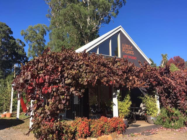
Little Fishes Gallery
1 Sedgwick St10 Falls Road
Marysville, Victoria
Call 0408 146 165
Warm and inviting studio space displaying local works, curated by an extremely personable and knowledgeable Bob McNamara. Be sure to include a stop at Little Fishes as part of your Marysville itinerary!
Essentials
The Marysville Grocer
Like many country supermarkets it is well stocked with fresh vegetables, bread, meat, dairy, spices, newspapers, alcohol, hardware needs etc.
The larger sister store operated by the same family is in Alexandra. Open daily except Christmas day from 7AM till 6PM
Large Coles supermarket.
Word has it that soon an Aldi will open on the main road in Healesville as well.
33 ντόπιοι το προτείνουν
Coles Healesville
251 Maroondah HwyLarge Coles supermarket.
Word has it that soon an Aldi will open on the main road in Healesville as well.
The larger sister store to the FoodWorks in Marysville.
Larger selection of everything including gluten free, dairy, vegetables, dry goods, liquor etc
6 ντόπιοι το προτείνουν
FoodWorks Alexandra
102 Grant StThe larger sister store to the FoodWorks in Marysville.
Larger selection of everything including gluten free, dairy, vegetables, dry goods, liquor etc
Shopping
Held at a picturesque setting at 11 Murchison Street in Marysville, this market is the perfect spot to buy some fresh produce, locally produced food items, confectionery and wines. In addition, you will also find stalls selling fragrances, lavender products, baked items and fruit-themed products.
9AM - 1PM every second and fourth Sunday of the month
Marysville Information & Regional Artspace
11 Murchison StHeld at a picturesque setting at 11 Murchison Street in Marysville, this market is the perfect spot to buy some fresh produce, locally produced food items, confectionery and wines. In addition, you will also find stalls selling fragrances, lavender products, baked items and fruit-themed products.
9AM - 1PM every second and fourth Sunday of the month
Getting Around
Bus Route 684: Melbourne - Marysville - Alexandra - Eildon
Phone: (03) 5962 5088
Email: mckenzies@bigpond.com
Contact: General Manager - Brad Sanders
After Hours: (03) 5962 1773 or 0429 139 899
Mckenzie's Tourist Services PTY LTD
13 Lilydale Road Bus Route 684: Melbourne - Marysville - Alexandra - Eildon
Phone: (03) 5962 5088
Email: mckenzies@bigpond.com
Contact: General Manager - Brad Sanders
After Hours: (03) 5962 1773 or 0429 139 899